
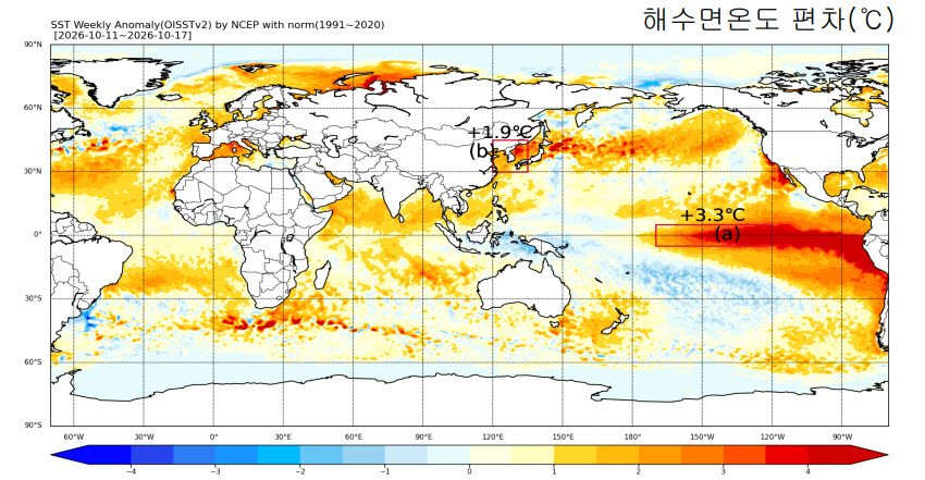
The strongest El Nino on record is expected to affect the Korean Peninsula throughout winter, bringing milder and wetter conditions, the Korea Meteorological Administration said Friday.
The El Nino, which started in May, is expected to strengthen the flow of warm and humid air toward Korea, potentially bringing higher temperatures and more precipitation through December. However, weather conditions could change sharply as cold air temporarily moves into the country in January, the KMA said.
El Nino is a climate phenomenon in which unusually warm surface waters in the central and eastern equatorial Pacific are accompanied by weakened trade winds, disrupting weather patterns around the world.
It is not a direct consequence of climate change but a naturally occurring climate pattern with records dating back to 1881. However, it affects weather patterns worldwide and can temporarily raise global temperatures.
The KMA defines the onset of El Nino as a period in which the three-month average sea surface temperature remains at least 0.5 degrees Celsius above the 1991-2020 average for five consecutive months.
The phenomenon has since intensified to its strongest level since Korean records began in 1950. In October, the sea surface temperature anomaly in the monitored region reached 2.6 C, while the three-month average through October exceeded 2.4 C, both marking record highs.
“As various climate factors interact, we also need to prepare for sudden weather changes, including cold snaps,” KMA Administrator Lee Mi-seon said.
The administration urged the public to follow its climate outlooks and short- and medium-range forecasts, noting that temperatures and precipitation could also be influenced by sea surface temperatures in the Indian and Atlantic oceans, Arctic sea ice and snow cover across Eurasia.
forestjs@heraldcorp.com