
Most Popular
-
1
Tensions heighten ahead of first president-opposition chief meeting

-
2
Seoul to provide housing subsidy to married couples with newborns

-
3
Rapper jailed after public street fight with another rapper

-
4
[KH Explains] No more 'Michael' at Kakao Games
![[KH Explains] No more 'Michael' at Kakao Games](//res.heraldm.com/phpwas/restmb_idxmake.php?idx=644&simg=/content/image/2024/04/28/20240428050183_0.jpg&u=20240428180321)
-
5
Woman gets suspended term for injuring boyfriend with knife


![[KH Explains] No more 'Michael' at Kakao Games](http://res.heraldm.com/phpwas/restmb_idxmake.php?idx=644&simg=/content/image/2024/04/28/20240428050183_0.jpg&u=20240428180321)

-
6
Yoon, Lee end first talks with differences, agree to meet more

-
7
[Grace Kao] Hybe vs. Ador: Inspiration, imitation and plagiarism
![[Grace Kao] Hybe vs. Ador: Inspiration, imitation and plagiarism](//res.heraldm.com/phpwas/restmb_idxmake.php?idx=644&simg=/content/image/2024/04/28/20240428050220_0.jpg&u=)
-
8
China outpaces Korea in smaller OLED shipments for 1st time

-
9
NewJeans pops out ‘Bubble Gum’ video amid troubles at agency

-
10
Samsung chief bolsters ties with Germany’s Zeiss


![[Grace Kao] Hybe vs. Ador: Inspiration, imitation and plagiarism](http://res.heraldm.com/phpwas/restmb_idxmake.php?idx=644&simg=/content/image/2024/04/28/20240428050220_0.jpg&u=)


Heading to the sunshine of Utah
Hiking at Zion National Park and golfing at St. George for the active traveler
By Lee Woo-youngPublished : Nov. 16, 2012 - 20:03
ST. GEORGE, Utah ― Pick your pleasure: Scrambling up a steep ridge, 1,000 feet above a canyon floor? Or gliding in a golf cart down a manicured fairway, where a carpet of emerald green offers a striking contrast to the red-rock desert?
At first blush, the two outings might seem to have little in common. But having done them on successive days in Southwest Utah this fall, I can identify two key similarities: Both call for sunscreen and each goes a lot better if you avoid going off a cliff.
Visiting the dramatic spires and vistas of Zion National Park has been on my to-do list for decades. And recently a friend mentioned that St. George, Utah, the closest sizable city, has become a bit of a golf Mecca.
That revelation, and a little online research, turned the matter from a notion into a plan: hiking boots and golf clubs were tossed into the Camry trunk for the two-day, 1,200-mile drive from Seattle.
Here’s a closer look at Zion hiking and a St. George round of golf:
Angels Landing
Somewhere along the steepest section of this 5.4-mile hike in Zion National Park, my right foot slipped a bit, dislodging a couple of dime-sized rock chips. They bounced once or twice and disappeared. I didn’t see them land. I knew they could be falling 1,000 feet or more.
This is what the news clippings had talked about. It’s why the park’s published guide says the Angels Landing hike is “not for young children or anyone fearful of heights.”
And it’s why a heavy chain is anchored to steel posts to assist hikers along the uppermost half-mile of this hike, which includes crossing a narrow rock “fin” with sheer drops on either side.
The Salt Lake Tribune has reported six fatalities in the last eight years along this route. (And in late October, a 49-year-old California man fell to his death on a technical climbing route below Angels Landing, a route that is not part of the trail.) When my foot slipped, I grasped the chain more tightly. And it took a few moments before I was ready for the next step.
Angels Landing, a hike that gains 1,488 feet, is in the “strenuous” category on the park’s guide, which also lists easy and moderate hikes.
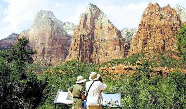
Zion, Utah’s most-visited national park, is known for its narrow canyons and layered sandstone cliffs in shades of red, tan and cream. Though the park is huge, at 229 square miles, visitor activity is centered along a 15-mile stretch of the Virgin River, which carved these rock faces over the eons.
One of the appeals of Angels Landing is that it provides breathtaking views almost from the start of the hike. The first two miles, wide and paved, end in “Walter’s Wiggles,” a set of 21 switchbacks built in the 1920s and named for Walter Ruesch, the park’s first custodian.
The “wiggles” lead to Scout Lookout, with views up and down the canyon. This is where my wife, Judy, saying she felt no need to prove her “manhood,” waited while I tackled the final section.
From Scout Lookout, it took about a half-hour, including stops for photos, to reach the top.
The payoff was a gently rounded summit, roughly the size of a 7-Eleven lot, with a magnificent 360-degree view. This may indeed attract angels in the next world. For now, it’s drawing visitors from all over this one. I overheard conversations in at least four languages.
Perhaps because I had read about the danger well before the trip, I found the hike a little less scary than I had expected ― but a little more strenuous, for a guy over 60. In one spot, I had to use the chain not just to hang onto, but to pull myself up, unclear where my foot should land.
The park’s guide says the Angels Landing Trail is best from March through October, but it can be hiked year-round as long as it’s free of ice and snow (and avoid it if there are high winds or thunderstorms).
On to the golf course
For Northwest golfers, a round of golf in southern Utah may be a bit jarring. We’re used to seeing tall evergreen trees (or rows of houses) flanking our fairways.
But guess what runs alongside several holes at Sand Hollow Golf Resort near St. George: Nothing.
Just left of the fairway, the earth disappears. It’s a 100-foot drop down to the valley floor, and if you just smacked your $4 Titleist Pro V1 that direction, the two of you are not going to be reunited in this lifetime.
Sand Hollow, listed by Golf Digest as one of the nation’s 10 best new courses in 2009, has strengthened St. George’s credentials as a year-round golf destination. Golfers can choose from a dozen courses in and around this city of 140,000, which sits at 2,800 feet.
With hot summers and mild winters, courses here present contrasts in bold colors: green grass, red-rock desert, black lava rock and blue sky.
At Sand Hollow’s 15th hole, a par-3 of 150 yards, I was determined to avoid the chasm on the left.
I succeeded ― but only by slicing far to the right, up a rocky slope.
After a brief search, I saw I’d suffered a common fate. Thought I didn’t find my ball, I did find four others. A double-bogey was a small price to pay for the adventure.
Speaking of price, I paid $55, including cart, to play Sand Hollow on a weekday in September, the last month of what the course calls its “offseason.” From Oct. 1 to mid-May, a round here is $100 Sunday-Thursday and $125 on Fridays, Saturdays and holidays.
With virtually no trees or water, the course defends itself with brick-red bunkers, undulating greens and patches of desert. Golfers decide how much of a challenge they want, with four sets of tees ranging from 5,306 to 7,315 yards. (From the 6,462-yard white tees, the course carries a rating of 69.6 and a slope of 126, meaning it’s a much tougher-than-average track.)
Shots tend to travel farther than at home here, due to the firm, dry fairways and the elevation.
Sand Hollow offers lower rates on its nearby nine-hole “Links Course,” laid out with a minimum amount of landscaping on flat desert terrain. A sign in desert grass off the first fairway warns “rattlesnake habitat.”
I also played another nearby course, Sky Mountain, which also has dramatic views but, with some bare patches on the greens, wasn’t in the same condition as Sand Hollow.
By Jack Broom
(The Seattle Times)
(MCT Information Services)


![[Herald Interview] Xdinary Heroes shoot for the next level with 'Troubleshooting'](http://res.heraldm.com/phpwas/restmb_idxmake.php?idx=642&simg=/content/image/2024/04/29/20240429050745_0.jpg&u=)