
Most Popular
-
1
'Super Rich in Korea' will leave viewers appreciating Korea more: producers

-
2
Probe of first lady on Dior bag allegations set to begin

-
3
Top prosecutor pledges 'speedy, strict' probe into first lady's luxury bag allegations

-
4
Indonesia’s KF-21 fighter jet deal cut back -- what’s next?

-
5
Korean battery makers heave sigh of relief over 2-year IRA reprieve


-
6
[KH Explains] Can tech firms' AI alliances take on Nvidia?
![[KH Explains] Can tech firms' AI alliances take on Nvidia?](//res.heraldm.com/phpwas/restmb_idxmake.php?idx=644&simg=/content/image/2024/05/07/20240507050619_0.jpg&u=)
-
7
Over 80,000 millionaires, 20 billionaires in Seoul: report

-
8
Police seek arrest warrant for med student who killed girlfriend

-
9
Local filmmakers criticize ‘The Roundup: Punishment’ monopoly of screens

-
10
Will China's self-sufficient dream in HBM come true?

![[KH Explains] Can tech firms' AI alliances take on Nvidia?](http://res.heraldm.com/phpwas/restmb_idxmake.php?idx=644&simg=/content/image/2024/05/07/20240507050619_0.jpg&u=)


The East Sea/Sea of Japan has a surface of 978,000 square kilometers, a maximum depth of 3,742 meters, and an average depth of 1752 m. This sea is a relatively wide and expansive sea bordered by Korea, Japan and Russia which stretches for about 1,100 km from Wonsanman Bay in the west to Hokkaido in the northeast and for about 1,700 km from the Korea Strait in the south to the Tartar Strait in the north.
The sea is connected with the East China Sea and the Pacific Ocean via the Korea Strait in the southwest, the Pacific Ocean in the east via the Tsugaru Strait which divides Honshu and Hokkaido, and the Sea of Okhotsk by both the La Pérouse (or Soya) Strait which separates Hokkaido from the Russian islands of Sakhalin and the Tartary Strait which separates Sakhalin from the eastern coast of Siberia. Without these four narrow channels, the sea would be an enclosed sea surrounded by land.
The “Sea of Japan,” -- the East Sea, is defined by the International Hydrographic Organization as comprising of the waters between the southern coast of the Korean Peninsula to Jeju Island, waters known as the South Sea in Korea, the Korea Strait (Busan in Korea to Fukuoka in Japan), and extends to the Northern extremity of the Tartary Strait.
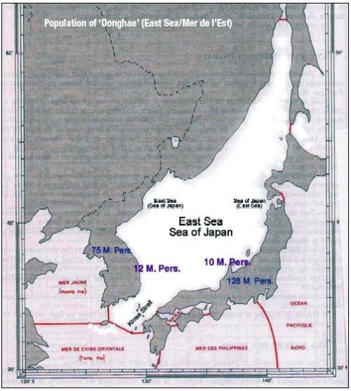
This sea has a total coastal length of 6,000 km of which 47 percent belongs to Russia, 36 percent to Japan and 16 percent to Korea. The sea offers a common space between four bordering countries: North Korea with 25 million inhabitants, South Korea 50 million, Japan 128 million and Russia 145 million. The population who live directly on the border of this sea account for roughly 12 million of the inhabitants of the south and east coasts of the Korean Peninsula, 10 million for the north and west coasts of the Japanese archipelago, and several millions for the Russian coasts on two sides of the Gulf of Tartary.
The four bordering countries each have their own territorial waters (22 kilometers from the coast), adjacent zone (44 kilometers), exclusive economic zone (EEZ, 370 kilometers), with the remaining portion being international waters. These four categories of maritime zone were defined by the Convention of the United Nations on the Right of the Sea in 1982, at the Convention of Montego Bay (Jamaica). South Korea and Japan are members of the convention.
The bordering countries have strategic and economic interests, as well as sharing the common responsibility for the sea: navigation (of warships and merchant ships), fisheries, natural resources, protection of the environment, meteorology, and so on.
In this sense, the name of the sea is very important. It must be used by everyone concerned.
Lee Ki-suk, former professor of geography at Seoul National University, former president of the East Sea Society and a member of the Academy of Sciences, said, “It is well-known that it took several centuries to correct a monumental collection of incorrect toponyms (geographical place names) in Ptolemy’s Atlas. … Everyone needs a place name to communicate with others, and then this place name becomes a key element for socio-economical activities, such as cartography, population census, pastimes and leisure activities, postal services, trading activities, etc. ”
Yu Woo-ik former professor of geography at Seoul National University, Korean ambassador in China and general secretary of the International Geographical Congress, expressed the same observation in August 2000: “A toponym implies a name given to a place by those whom it belongs to or by those who make use of it, or else by those who are merely concerned.”
“Naming a place is the same as assuming possession over it. Or, trying to do so. A seemingly neutral toponym is actually a high-stakes issue, the stakes increase when there is a dispute over a geographical space among several parties,” wrote Philippe Pelletier, professor of geography at the Lumière University, in Lyon, France.
The toponyms are carried, diffused and fixed through geographical maps and atlases.
East Sea / Sea of Japan
The problem posed is that the sea between Korea and Japan bears the name “Sea of Japan,” used in the outside world, but unknown by Koreans directly concerned.
The name “Donghae” (East Sea) is unknown to the Japanese, and “Nihon-kai” (Sea of Japan) unknown to Koreans. If a name for a sea is not recognized by the persons concerned, both “Donghae / Nihon-kai” need to be used for the persons involved to grasp which sea is quoted, and this until everybody involved in the matter has agreed upon a neutral and pretty name, symbolizing the geographical nature as well as the human surroundings of the sea in question.
Furthermore, the name “Sea of Japan” has a connotation implying that the sea “belongs to” Japan or the sea is the “property” of Japan. Koreans feel frustrated and indignant when they discover the name “Sea of Japan” on foreign maps for the sea they call Donghae (East Sea).
The two Koreas joined the U.N. in 1991. In 1992, South Korea participated in the U.N. Conference on Standardization of Geographical Names for the first time. On that occasion, the Korean delegation claimed the name East Sea, used since antiquity in Korea, for the sea known as the Sea of Japan. The name is something that Koreans can not easily accept because of the memory of Japanese colonization. Koreans think the sea name relates to their dignity, honor and pride. It’s also a question of affirmation of their national identity in the international community.
Koreans see the name Sea of Japan as a historical injustice because the toponym wasonfirmed by the IHO in 1929 when Korea was a colony of Japan. South Korea became a member of the IHO in 1957, and sent its delegation for the first time in 1962.
The IHO established the document entitled “Limits of the Oceans & Seas” (S-23), an international reference for hydrography. The third version of S-23 is under revision. South Korea argued in 1994 for the inscription of the East Sea beside the Sea of Japan in this document. On Aug. 15, 2002, the IHO sent its proposal of S-23 for the vote of the 72 member countries. In the draft, both names were mentioned for the sea in question. South Korea expressed its relative satisfaction, while Japan was surprised. Japan acted rapidly and succeeded in getting the IHO to drop the draft.
Japan is determined to defend the name “Sea of Japan.” The question of naming this sea is a major diplomatic issue between Korea and Japan, toward international communities (U.N., IHO), geographers, cartographers, editors, and mass media of the third countries.
Local name is favored by international organizations
The name “Donghae” (East Sea / Mer de l’Est) is the only endonym -- local name -- for the sea between Korea and Japan that was definitely established in the Korean Peninsula since antiquity, and is still used today. The East Sea is, in this sense, an inalienable item of Korean cultural heritage. But this name has not yet sufficiently acquired usage abroad because people there have been unaware of it until now. Koreans are also responsible for this situation by their ignorance of the matters on the international scene until the beginning of 1990s.
But it’s not too late to recognize this historically proven evidence, and repair the error of history, and begin to adopt the double name East Sea / Sea of Japan.
The Japanese adopted the name “Sea of Japan” (Nihonkai / Mer du Japon), used on the Western maps widely since the beginning of the 19th century. These maps were introduced after the Meiji Restoration in 1868. This means that Sea of Japan is an exonym (foreign name) of Western origin, adopted and rapidly appropriated by Japanese. For this reason, the Sea of Japan doesn’t appear in any ancient Japanese document prior to the mid-19th century.
It’s only common sense that international communities use East Sea beside Sea of Japan so that Koreans can understand the location relevant to multiple purposes: Navigation, maritime accidents, fishing, natural resources, the environment and meteorology.
Desirable toponym
A place name in a country can be revised by the national commission of standardization of geographical names. Traditionally, the name of seas, gulfs and mountains broaching several countries is fixed by frequency of use, by custom and tradition. Nowadays, an international geographical name is defined, adopted or recommended by the international organizations such as the IHO for the limits and the name of seas and oceans, and by the U.N. Conference of Standardization of Geographical Names for general toponyms. In this last case, the problem is not so simple to resolve if there are several names for one geographical space, defended by several countries. For this purpose, the international authorities have recommendations.
The IHO’s resolution of 1974 recommends that the name forms of each of the languages in question should be accepted for charts and publications unless technical reasons prevent this practice on small scale charts; e.g., English Channel / La Manche. The legitimacy of the place or sea name can be contested if it is acquired by a decision taken unilaterally, if it is not founded on the common accord between the parties directly concerned, or if it is not based on the historically and scientifically irrefutable proofs issued from the facts of the involved countries, not from a third party. In this case, a contested name such as Sea of Japan can bear some tension between the protagonist countries.
The U.N. resolution on geographical names goes along the same lines.
U.N. Resolution on geographical names; III/20, 1977, names of features beyond a single sovereignty: the Conference for Geographical Standard Names, considering the need for international standardization of names of geographical features that are divided among two or more countries, makes two main recommendations. Firstly, it recommends that countries sharing a given geographical feature under different names should endeavor, as far as possible, to reach agreement on fixing a single name for the feature concerned. It further recommends that when countries sharing a given geographical feature do not succeed in agreeing on a common name, it should be a general rule of international cartography that to use one name while excluding the rest would be inconsistent in principle as well as inexpedient in practice. Only technical reasons may sometimes make it necessary, especially in the case of small-scale, to dispense with the use of certain names belonging to one language or another.”
In principle, nothing is definitive. A sea name can be changed by a common decision between the countries implied. A name is never given by the force of law. A geographical name is acquired by empirical practices and by the frequency and the expanse of its use. They can also come from an image, an icon, a symbol or a representation charged of sentiment and emotion of the people concerned.
The sea located between Korea, Far East Russia and Japan, is not an exception.
On April 8, 2008, Google adopted Primary Local Usage Policy for the name of the sea between Korea and Japan. Google’s policy is to conform to the U.N. resolution. Google justified its policy in these terms: “As the publishers of a geographic reference tool, we believe that Google should not choose sides in international geographical disputes. For this reason, we’ve chosen to implement a uniform policy of Primary Local Usage. This policy is based on the principle of usage of ‘primary, common, local’ usage of geographical names. (…) This policy consists in writing on those maps the various names used by different countries, ethnic groups, or in different languages, to refer to the name, common places. The adopted names are transcribed or translated into equivalent terms in different languages, varying with each linguistic version of Google Earth. As a result, East Sea / Sea of Japan in original English version is translated into “Mer de l’Est / Mer du Japon” in French.
Google’s Primary Local Usage Policy should be a model that the other cartographers have to follow, waiting for the adoption of a name acceptable to all parties concerned.
By Li Jin-mieung
The sea is connected with the East China Sea and the Pacific Ocean via the Korea Strait in the southwest, the Pacific Ocean in the east via the Tsugaru Strait which divides Honshu and Hokkaido, and the Sea of Okhotsk by both the La Pérouse (or Soya) Strait which separates Hokkaido from the Russian islands of Sakhalin and the Tartary Strait which separates Sakhalin from the eastern coast of Siberia. Without these four narrow channels, the sea would be an enclosed sea surrounded by land.
The “Sea of Japan,” -- the East Sea, is defined by the International Hydrographic Organization as comprising of the waters between the southern coast of the Korean Peninsula to Jeju Island, waters known as the South Sea in Korea, the Korea Strait (Busan in Korea to Fukuoka in Japan), and extends to the Northern extremity of the Tartary Strait.
This sea has a total coastal length of 6,000 km of which 47 percent belongs to Russia, 36 percent to Japan and 16 percent to Korea. The sea offers a common space between four bordering countries: North Korea with 25 million inhabitants, South Korea 50 million, Japan 128 million and Russia 145 million. The population who live directly on the border of this sea account for roughly 12 million of the inhabitants of the south and east coasts of the Korean Peninsula, 10 million for the north and west coasts of the Japanese archipelago, and several millions for the Russian coasts on two sides of the Gulf of Tartary.
The four bordering countries each have their own territorial waters (22 kilometers from the coast), adjacent zone (44 kilometers), exclusive economic zone (EEZ, 370 kilometers), with the remaining portion being international waters. These four categories of maritime zone were defined by the Convention of the United Nations on the Right of the Sea in 1982, at the Convention of Montego Bay (Jamaica). South Korea and Japan are members of the convention.
The bordering countries have strategic and economic interests, as well as sharing the common responsibility for the sea: navigation (of warships and merchant ships), fisheries, natural resources, protection of the environment, meteorology, and so on.
In this sense, the name of the sea is very important. It must be used by everyone concerned.

Lee Ki-suk, former professor of geography at Seoul National University, former president of the East Sea Society and a member of the Academy of Sciences, said, “It is well-known that it took several centuries to correct a monumental collection of incorrect toponyms (geographical place names) in Ptolemy’s Atlas. … Everyone needs a place name to communicate with others, and then this place name becomes a key element for socio-economical activities, such as cartography, population census, pastimes and leisure activities, postal services, trading activities, etc. ”
Yu Woo-ik former professor of geography at Seoul National University, Korean ambassador in China and general secretary of the International Geographical Congress, expressed the same observation in August 2000: “A toponym implies a name given to a place by those whom it belongs to or by those who make use of it, or else by those who are merely concerned.”
“Naming a place is the same as assuming possession over it. Or, trying to do so. A seemingly neutral toponym is actually a high-stakes issue, the stakes increase when there is a dispute over a geographical space among several parties,” wrote Philippe Pelletier, professor of geography at the Lumière University, in Lyon, France.
The toponyms are carried, diffused and fixed through geographical maps and atlases.
East Sea / Sea of Japan
The problem posed is that the sea between Korea and Japan bears the name “Sea of Japan,” used in the outside world, but unknown by Koreans directly concerned.
The name “Donghae” (East Sea) is unknown to the Japanese, and “Nihon-kai” (Sea of Japan) unknown to Koreans. If a name for a sea is not recognized by the persons concerned, both “Donghae / Nihon-kai” need to be used for the persons involved to grasp which sea is quoted, and this until everybody involved in the matter has agreed upon a neutral and pretty name, symbolizing the geographical nature as well as the human surroundings of the sea in question.
Furthermore, the name “Sea of Japan” has a connotation implying that the sea “belongs to” Japan or the sea is the “property” of Japan. Koreans feel frustrated and indignant when they discover the name “Sea of Japan” on foreign maps for the sea they call Donghae (East Sea).
The two Koreas joined the U.N. in 1991. In 1992, South Korea participated in the U.N. Conference on Standardization of Geographical Names for the first time. On that occasion, the Korean delegation claimed the name East Sea, used since antiquity in Korea, for the sea known as the Sea of Japan. The name is something that Koreans can not easily accept because of the memory of Japanese colonization. Koreans think the sea name relates to their dignity, honor and pride. It’s also a question of affirmation of their national identity in the international community.
Koreans see the name Sea of Japan as a historical injustice because the toponym wasonfirmed by the IHO in 1929 when Korea was a colony of Japan. South Korea became a member of the IHO in 1957, and sent its delegation for the first time in 1962.
The IHO established the document entitled “Limits of the Oceans & Seas” (S-23), an international reference for hydrography. The third version of S-23 is under revision. South Korea argued in 1994 for the inscription of the East Sea beside the Sea of Japan in this document. On Aug. 15, 2002, the IHO sent its proposal of S-23 for the vote of the 72 member countries. In the draft, both names were mentioned for the sea in question. South Korea expressed its relative satisfaction, while Japan was surprised. Japan acted rapidly and succeeded in getting the IHO to drop the draft.
Japan is determined to defend the name “Sea of Japan.” The question of naming this sea is a major diplomatic issue between Korea and Japan, toward international communities (U.N., IHO), geographers, cartographers, editors, and mass media of the third countries.
Local name is favored by international organizations
The name “Donghae” (East Sea / Mer de l’Est) is the only endonym -- local name -- for the sea between Korea and Japan that was definitely established in the Korean Peninsula since antiquity, and is still used today. The East Sea is, in this sense, an inalienable item of Korean cultural heritage. But this name has not yet sufficiently acquired usage abroad because people there have been unaware of it until now. Koreans are also responsible for this situation by their ignorance of the matters on the international scene until the beginning of 1990s.
But it’s not too late to recognize this historically proven evidence, and repair the error of history, and begin to adopt the double name East Sea / Sea of Japan.
The Japanese adopted the name “Sea of Japan” (Nihonkai / Mer du Japon), used on the Western maps widely since the beginning of the 19th century. These maps were introduced after the Meiji Restoration in 1868. This means that Sea of Japan is an exonym (foreign name) of Western origin, adopted and rapidly appropriated by Japanese. For this reason, the Sea of Japan doesn’t appear in any ancient Japanese document prior to the mid-19th century.
It’s only common sense that international communities use East Sea beside Sea of Japan so that Koreans can understand the location relevant to multiple purposes: Navigation, maritime accidents, fishing, natural resources, the environment and meteorology.
Desirable toponym
A place name in a country can be revised by the national commission of standardization of geographical names. Traditionally, the name of seas, gulfs and mountains broaching several countries is fixed by frequency of use, by custom and tradition. Nowadays, an international geographical name is defined, adopted or recommended by the international organizations such as the IHO for the limits and the name of seas and oceans, and by the U.N. Conference of Standardization of Geographical Names for general toponyms. In this last case, the problem is not so simple to resolve if there are several names for one geographical space, defended by several countries. For this purpose, the international authorities have recommendations.
The IHO’s resolution of 1974 recommends that the name forms of each of the languages in question should be accepted for charts and publications unless technical reasons prevent this practice on small scale charts; e.g., English Channel / La Manche. The legitimacy of the place or sea name can be contested if it is acquired by a decision taken unilaterally, if it is not founded on the common accord between the parties directly concerned, or if it is not based on the historically and scientifically irrefutable proofs issued from the facts of the involved countries, not from a third party. In this case, a contested name such as Sea of Japan can bear some tension between the protagonist countries.
The U.N. resolution on geographical names goes along the same lines.
U.N. Resolution on geographical names; III/20, 1977, names of features beyond a single sovereignty: the Conference for Geographical Standard Names, considering the need for international standardization of names of geographical features that are divided among two or more countries, makes two main recommendations. Firstly, it recommends that countries sharing a given geographical feature under different names should endeavor, as far as possible, to reach agreement on fixing a single name for the feature concerned. It further recommends that when countries sharing a given geographical feature do not succeed in agreeing on a common name, it should be a general rule of international cartography that to use one name while excluding the rest would be inconsistent in principle as well as inexpedient in practice. Only technical reasons may sometimes make it necessary, especially in the case of small-scale, to dispense with the use of certain names belonging to one language or another.”
In principle, nothing is definitive. A sea name can be changed by a common decision between the countries implied. A name is never given by the force of law. A geographical name is acquired by empirical practices and by the frequency and the expanse of its use. They can also come from an image, an icon, a symbol or a representation charged of sentiment and emotion of the people concerned.
The sea located between Korea, Far East Russia and Japan, is not an exception.
On April 8, 2008, Google adopted Primary Local Usage Policy for the name of the sea between Korea and Japan. Google’s policy is to conform to the U.N. resolution. Google justified its policy in these terms: “As the publishers of a geographic reference tool, we believe that Google should not choose sides in international geographical disputes. For this reason, we’ve chosen to implement a uniform policy of Primary Local Usage. This policy is based on the principle of usage of ‘primary, common, local’ usage of geographical names. (…) This policy consists in writing on those maps the various names used by different countries, ethnic groups, or in different languages, to refer to the name, common places. The adopted names are transcribed or translated into equivalent terms in different languages, varying with each linguistic version of Google Earth. As a result, East Sea / Sea of Japan in original English version is translated into “Mer de l’Est / Mer du Japon” in French.
Google’s Primary Local Usage Policy should be a model that the other cartographers have to follow, waiting for the adoption of a name acceptable to all parties concerned.
By Li Jin-mieung


![[K-pop’s dilemma] Time, profit pressures work against originality](http://res.heraldm.com/phpwas/restmb_idxmake.php?idx=652&simg=/content/image/2024/05/08/20240508050705_0.jpg&u=20240508171126)
![[Today’s K-pop] NCT Dream to drop pre-release from 2nd Japan single](http://res.heraldm.com/phpwas/restmb_idxmake.php?idx=642&simg=/content/image/2024/05/08/20240508050725_0.jpg&u=)