Most Popular
-
1
[Exclusive] Korean military set to ban iPhones over 'security' concerns
![[Exclusive] Korean military set to ban iPhones over 'security' concerns](//res.heraldm.com/phpwas/restmb_idxmake.php?idx=644&simg=/content/image/2024/04/23/20240423050599_0.jpg&u=20240423183955)
-
2
Korean, Romanian leaders discuss defense tech, nuclear energy
-
3
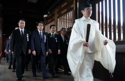
S. Korea calls on Japan to confront history amid Yasukuni Shrine visit
-
4
Yoon’s jailed mother-in-law excluded from latest parole list

-
5
Hybe and Min Hee-jin, CEO of Hybe sublabel Ador, lock horns

![[Exclusive] Korean military set to ban iPhones over 'security' concerns](http://res.heraldm.com/phpwas/restmb_idxmake.php?idx=644&simg=/content/image/2024/04/23/20240423050599_0.jpg&u=20240423183955)


-
6
[Herald Interview] 'Amid aging population, Korea to invite more young professionals from overseas'
![[Herald Interview] 'Amid aging population, Korea to invite more young professionals from overseas'](//res.heraldm.com/phpwas/restmb_idxmake.php?idx=644&simg=/content/image/2024/04/24/20240424050844_0.jpg&u=20240424200058)
-
7
Korea’s homegrown nanosatellite successfully launches into space

-
8
[Pressure points] Leggings in public: Fashion statement or social faux pas?
![[Pressure points] Leggings in public: Fashion statement or social faux pas?](//res.heraldm.com/phpwas/restmb_idxmake.php?idx=644&simg=/content/image/2024/04/23/20240423050669_0.jpg&u=)
-
9
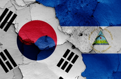
Nicaragua shuts down Seoul embassy
-
10
Rocket engine expert, ex-NASA exec to lead Korea's new space agency

![[Herald Interview] 'Amid aging population, Korea to invite more young professionals from overseas'](http://res.heraldm.com/phpwas/restmb_idxmake.php?idx=644&simg=/content/image/2024/04/24/20240424050844_0.jpg&u=20240424200058)

![[Pressure points] Leggings in public: Fashion statement or social faux pas?](http://res.heraldm.com/phpwas/restmb_idxmake.php?idx=644&simg=/content/image/2024/04/23/20240423050669_0.jpg&u=)


S. Korea dodges two typhoons, but a third could hit
Tropical depression over waters of Okinawa could develop into a typhoon and hit the country, weather forecaster says
By Shim Woo-hyunPublished : Sept. 13, 2022 - 16:15
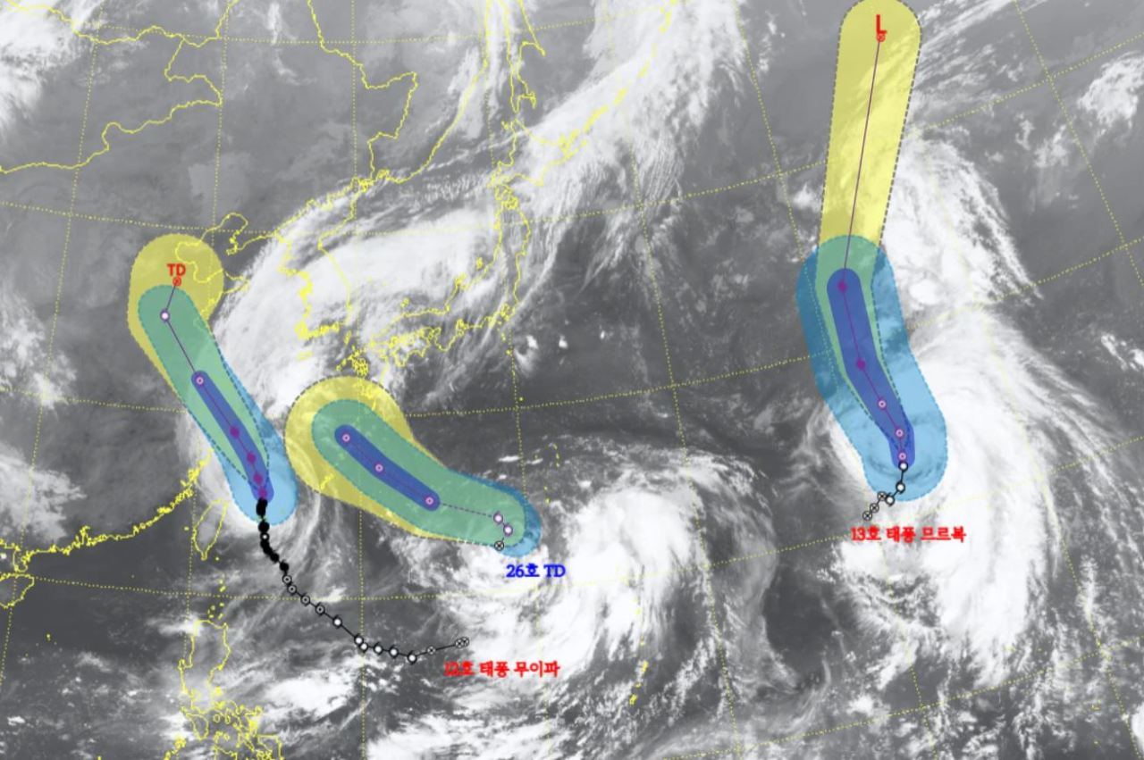
South Korea will be safe from two typhoons that have formed to the south of the peninsula, but another typhoon could become active over the waters off of Japan's Okinawa and hit the country, the state weather agency said Tuesday.
Typhoon Muifa, the 12th tropical storm this year, was moving northward over waters 260 kilometers east of Taipei at a speed of 8 kilometers per hour as of 3 a.m. Tuesday, according to the Korea Meteorological Administration,
The typhoon has a central pressure of 965 hectopascals and winds reaching up to 37 meters per second (133 kilometers per hour). It is classified as "strong," the third-highest level in the state weather agency's four-tier system.
Typhoon Muifa will not directly hit South Korea but move toward China and reach the eastern coast off Shanghai on Thursday.
Jeju Island, however, is expected to see precipitation between 30 and 100 millimeters by Wednesday, while other coastal regions on the western part of the country could see 10-50 mm of precipitation.
Another typhoon, Typhoon Merbok, the 13th of the year, will not likely be a threat to the Korean Peninsula either. As of 3 a.m. Tuesday, Typhoon Merbok was moving northward over waters 2,610 kilometers east-southeast of Tokyo.
The state weather agency said the typhoon will continue to move northward and disappear on Friday. South Korea will not be influenced by the typhoon due to the distance.
Although South Korea will be able to dodge the two typhoons that come on the heels of the devastating Typhoon Hinnamnor, there is still a possibility that a tropical depression in waters off of Japan's Okinawa could develop into a typhoon. If so, it will be named Nanmadol and potentially affect the Korean Peninsula.
The tropical depression was moving northward over waters 1,130 km east-southeast of Okinawa as of 3 a.m. Tuesday.
The tropical depression’s path will become clearer later this week as its path and speed can be influenced by Typhoon Muifa, according to the state weather agency.
The KMA said that this tropical depression was not volatile yet, with a central pressure of 998 hectopascals and winds reaching up to 21 meters per second (76 kilometers per hour) as of early Tuesday morning.
-
Articles by Shim Woo-hyun