Most Popular
-
1
Korea’s homegrown nanosatellite successfully launches into space

-
2
Ador CEO denies allegations, accuses Hybe of mistreating NewJeans

-
3
[Herald Interview] 'Amid aging population, Korea to invite more young professionals from overseas'
![[Herald Interview] 'Amid aging population, Korea to invite more young professionals from overseas'](//res.heraldm.com/phpwas/restmb_idxmake.php?idx=644&simg=/content/image/2024/04/24/20240424050844_0.jpg&u=20240424200058)
-
4
Nicaragua shuts down Seoul embassy

-
5
Hybe's multilabel system tested amid conflict with Ador


![[Herald Interview] 'Amid aging population, Korea to invite more young professionals from overseas'](http://res.heraldm.com/phpwas/restmb_idxmake.php?idx=644&simg=/content/image/2024/04/24/20240424050844_0.jpg&u=20240424200058)


-
6
Rocket engine expert, ex-NASA exec to lead Korea's new space agency

-
7
SNU profs to suspend treatment for one day

-
8
SK hynix pledges W20tr to ramp up DRAM production at home

-
9
Over-50s, men, single-person households take up majority of those filing for bankruptcy

-
10
Pianist Cho Seong-Jin named Berlin Philharmonic's artist-in-residence


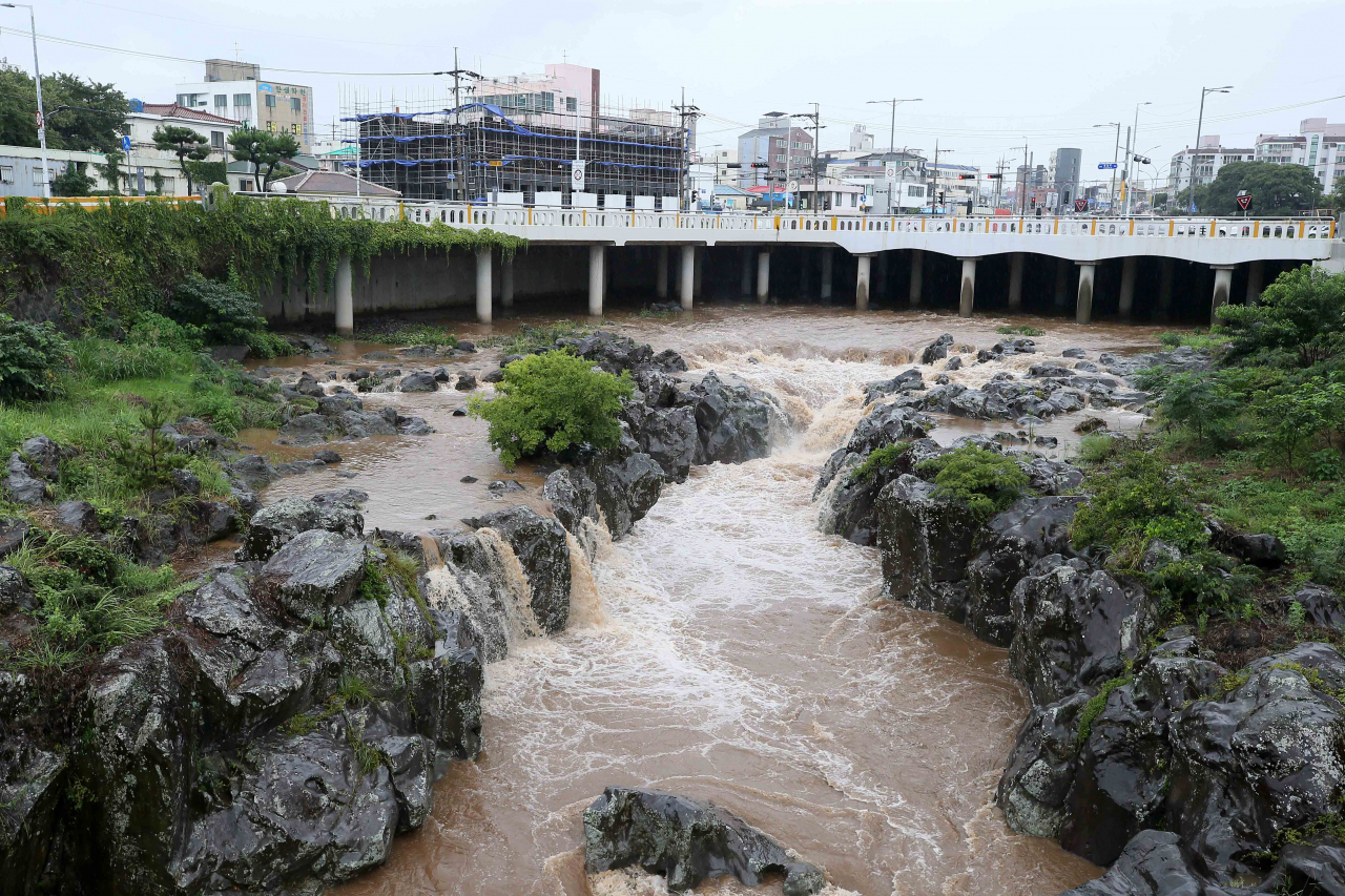
Super Typhoon Hinnamnor has gradually moved northward to reach waters off the southern island of Jeju on Monday, the state weather agency said, as South Korea braces for what could be the most powerful storm ever to hit the country.
As of 5 a.m., the typhoon, the 11th this year, was located 550 kilometers south-southwest of Jeju's Seogwipo, moving north at a speed of 22 kilometers per hour, according to the Korea Meteorological Administration (KMA).
The speed is faster than an earlier estimate of 12 km per hour, and the typhoon is classified as a "very strong" typhoon packing a maximum sustained wind speed of 49 meters per second.
Typhoons are classified into four categories: medium, strong, very strong and super strong. Super strong refers to typhoons with a maximum wind speed of at least 54 meters per second.
After brushing past Jeju, Typhoon Hinnamnor is forecast to gain momentum to make landfall 80 km north-northwest of the southern port city of Busan by 9 a.m. Tuesday, with an atmospheric pressure of 955 hectopascals at its center, according to the KMA.
The typhoon's strength when it reaches Busan is forecast to weaken to "strong," although it is expected to become the strongest typhoon ever to make landfall in South Korea.
Hinnamnor is forecast to maintain its strength after passing through the Korean Peninsula, the KMA said.
A heavy rain warning was issued for all parts of the country until Tuesday, the KMA said.
The country is expected to receive an accumulated rainfall between 100 and 300 millimeters on Monday and Tuesday, with the mountainous areas of Jeju and some southern coastal regions receiving more than 600 millimeters and 400 millimeters, respectively, the KMA said.
The typhoon could also bring record strong winds, with the KMA forecasting maximum speeds of 40 to 60 meters per second in Jeju and other lower coastal areas between Monday night and Tuesday.
The current record is 63.7 meters per second measured in the eastern coastal city of Sokcho on Oct. 23, 2006.
No casualties have been reported from the effects of Typhoon Hinnamnor so far.
The Central Disaster and Safety Countermeasures Headquarters' emergency response posture was upgraded to the highest level as of 4:30 p.m. Sunday for the first time in five years in terms of the typhoon response.
A series of ferry services and flights were canceled across the country.
Out of 67 domestic flights leaving the Gimpo International Airport, located just west of Seoul, as of 9 a.m. Monday, 13 had been cancelled, according to airport authorities.
Across the country, a total of 38 domestic flights were cancelled, in addition to 294, according to the Korea Airports Corporation.
The government also recommended schools skip classes or switch to online learning and private companies adjust work hours Tuesday morning, when Hinnamnor is expected to make landfall. (Yonhap)


![[KH Explains] Korean shipbuilding stocks rally: Real growth or bubble?](http://res.heraldm.com/phpwas/restmb_idxmake.php?idx=652&simg=/content/image/2024/04/25/20240425050656_0.jpg&u=)