
Most Popular


-
6
[KH Explains] How should Korea adjust its trade defenses against Chinese EVs?
![[KH Explains] How should Korea adjust its trade defenses against Chinese EVs?](//res.heraldm.com/phpwas/restmb_idxmake.php?idx=644&simg=/content/image/2024/04/15/20240415050562_0.jpg&u=20240415144419)
-
7
BTS' Jungkook creates Instagram account for his dog
-
8
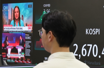
Korea braces for blows from Middle East conflict
-
9
Seoul says will cut power to porn festival planned on Han River
-
10
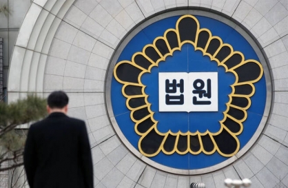
Recording of boss cursing in office ruled legal
![[KH Explains] How should Korea adjust its trade defenses against Chinese EVs?](http://res.heraldm.com/phpwas/restmb_idxmake.php?idx=644&simg=/content/image/2024/04/15/20240415050562_0.jpg&u=20240415144419)


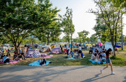
So what have I noticed? After more than two years of pandemic precautions, Seoul looks different. I’ve noticed lots of little parks dotted around crowded older neighborhoods. Many are so small that they appear only after zooming in, but they offer much-needed greenery.
I’ve also noticed the many long parks for walking. “Yeontral Park” near Exit 3 of Hongik Univ. Station is famous, but it is the last leg of the long Gyeongui Line Forest Park that replaced railroad tracks that were moved underground. From end to end, the walk is 6.3 kilometers long and makes for a good weekend hike. A similar park, the 6.0-kilometer-long Gyeongchun Line Forest Trail, replaced railroad tracks in the northeast corner of the city.
Other walking parks follow streams that had previously been covered in concrete to make roads for the booming city in the 1960s and 1970s. Cheonggyecheon in the center of Seoul is the most famous example. The uncovered and restored part of the watercourse runs 5.8 kilometers but continues to the Han River making for a total of 10.8 kilometers. Lesser-known parks along streams are found throughout the city. Parts of the Seongbukcheon near Hansung Univ. Station were uncovered and turned into a walking course. Hikers can now walk the 5.0-kilometer course until it meets the middle section of Cheonggyecheon. In the mid-1990s, the flow of water to the Yangjaecheon was restored and the banks developed into a nature walk that runs 16.6 kilometers from Jamsil to Gwacheon.
Added together, these railroad and stream parks make up an extensive network of walking routes throughout the city. This is in addition to the lengthy hiking courses in the mountains in the city. As I clicked around, I began to view them like long color-coded subway lines stringing around the city. They offer citizens, most of whom live in dense apartment buildings, a chance to get out and walk. These parks help busy people fit exercise into their daily routines because they are free and easily accessible.
Maps also show how the 21st century layout of Seoul is diverging from its 20th century footprint. Density in most 20th century cities was a pattern of rings of decreasing density surrounding a dense commercial core which was also the oldest part of the city. With the development of Yeouido and Gangnam in the 1970s, Seoul began to diverge from this pattern. By the 1990s, Seoul had three major commercial cores surrounded by rings of decreasing density.
The map of the city began to change in the 2000s as waves of redevelopment turned lower-density areas into ever taller and denser apartment complexes. Apartment complexes increasingly dominate the cityscape with areas of low-rise densely packed housing squeezed between them.
Interestingly, the spread of apartment complexes has increased green space. Regulations require developers to provide green space, but generous height allowances keep the projects profitable. Unlike the small parks and walking parks, this is private green space only for residents of the complex, but each redevelopment project adds more green space to Seoul.
After hours of clicking away at maps, I realized that Seoul has much more greenery than people give it credit for. It lacks a famous park like Central Park in New York or Hyde Park in London, but these cities do not have mountains and an extensive network of railroad and stream parks. In the nearly 30 years since local elections began, Seoul has made substantial progress in carving out unique green spaces.
So where does Seoul go from? Switching from map to street view helps answer this question. Major streets are lined with trees and orderly traffic, but streets in older neighborhoods that are sandwiched among apartment complexes are crowded and treeless. Pedestrians and cars compete for road space because there are no sidewalks. Improving walkability, even in small ways, will go a long way in improving the quality of life.
Robert J. Fouser
Robert J. Fouser, a former associate professor of Korean language education at Seoul National University, writes on Korea from Providence, Rhode Island. He can be reached at robertjfouser@gmail.com. -- Ed.
-
Articles by Korea Herald


![[Today’s K-pop] Stray Kids to return soon: report](http://res.heraldm.com/phpwas/restmb_idxmake.php?idx=642&simg=/content/image/2024/04/16/20240416050713_0.jpg&u=)