

Most Popular
-
1
Yoon sorry for shortcomings but insists policies were right

-
2
1 in 3 Koreans live alone, family types becoming diverse

-
3
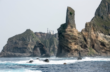
S. Korea ‘strongly’ protests Japan’s claim over Dokdo in diplomatic bluebook
-
4
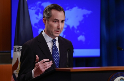
US 'incredibly concerned' about suspected NK-Iran military ties
-
5
Korea, Japan finance chiefs vow to tame rampant FX market volatility


-
6
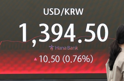
Korean won weakens amid heightened uncertainty
-
7
Seoul says will cut power to porn festival planned on Han River

-
8
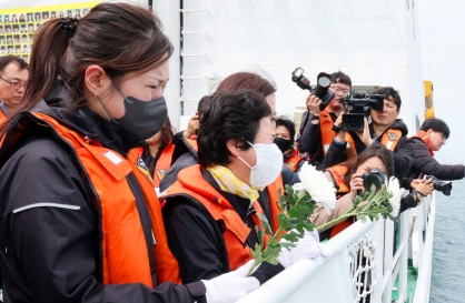
Sewol victims commemorated on tragedy's 10th anniversary
-
9
K-pop group's manager dismissed for setting up spycam in theater dressing room

-
10
Chanel, Louis Vuitton see muted growth in Korea


[Roger Bilham] Japan’s megaquake is template for U.S. west coast
By 류근하Published : March 24, 2011 - 18:27
As the world’s attention remains fixed on Japan’s crippled nuclear reactors, scientists are beginning to understand the details of the megaquake that brought so much ruin to Japan, saying it’s probably the largest temblor to hit the nation in 1,000 years.
Seismologists have known for some time that over periods of millennia such megaquakes occur. They pack the punch of three or more major earthquakes into a single tumultuous rupture, allowing several segments of long straight tectonic plate boundaries to catch up with a handful of inefficient adjustments that arose in the past several hundred years.
The rarity of these events makes them difficult to study, much less forecast, but we’ve now had three in less than a decade: the 2004 Sumatra earthquake released twice as much energy as the recent one in Japan, and last year’s Chilean earthquake produced half as much. Clearly the time has come for scientists to take up the challenge of working harder to try forecasting these extreme geological events.
The March 11 earthquake ruptured a 300-by-100 square mile area of the Pacific plate where it plunges into the Earth’s mantle under Honshu, north of Tokyo. In the past few hundred years, earthquakes in the same region, though damaging, were smaller, even if sometimes spawning monster tsunami with heights near the epicenters exceeding 90 feet (27 meters).
Scientists expected more modest events, yet what happened was stunningly different ― segments of the plate boundary that had slipped more or less regularly, teamed up with those that had been hung-up for centuries, in places driven by more than 50 feet of pent-up Pacific displacements.
The earthquake has caused major changes to the Pacific coastline north of Tokyo. Thanks to several hundred global positioning units that operated every 5 seconds during the earthquake, we know that in less than 3 minutes the island of Honshu expanded westward by up to 12 feet, adding acreage equivalent to 150 soccer fields.
Like a stretched-out rubber band that’s been cut, the coastal city of Sendai near the epicenter moved first 15 feet toward the U.S. and then in the next 50 seconds snapped back 3 feet to where it now remains. Once the aftershocks are over, the slow, inexorable compression of northern Japan will renew, leading to more earthquakes.
Yet it is the vertical motion of the Japanese coastline that has caused the most serious of the nation’s post-earthquake disasters, and was least anticipated by seismologists. The whole of Honshu has sunk a little ― Tokyo itself by more than 4 inches and increasing northward. Starting some 50 miles north of Tokyo and extending to near the northern tip of the island of Honshu, the coastline sank not because of slumping or compaction of coastal sediments, but due to the elastic rebound toward the epicenter.
These same elastic stresses 10 miles to 100 miles offshore warped a broad 10-foot to 15-foot bulge in the sea floor that generated the disastrous tsunami. Thirty minutes later the tsunami surged onshore as a wall of water up to 45 feet high. Simultaneously, a mirror image of the tsunami raced eastward at 500 mph (805 kph), splashing sequentially the shores of Hawaii, and coastal communities from Alaska to Patagonia, ultimately raising global sea level globally by 1/100 of an inch.
Had Japan’s eastern shore not sunk as the sea surged toward it, the tsunami that drove onshore would have been less damaging, and its aftermath less tragic. Port facilities, beaches and most important, the 16-foot-high tsunami barriers for the Fukushima nuclear power plant, were lowered 3 feet by the earthquake. The barriers needed to be twice as high to avoid flooding of the facility.
The nightmare scenario now unfolding in Japan could get worse. Seismologists have documented numerous times when an earthquake in one place has stressed a neighboring area, triggering another major tremor.
Could this month’s earthquake trigger what Japanese call the Tokai earthquake, which last ruptured the region south of Tokyo in 1854? With a recurrence interval of 110 years, Tokyo’s residents know this event is overdue. Ominous aftershocks have been approaching Tokyo daily since March 11. A few sizeable aftershocks have even migrated to its south.
Have U.S. seismologists been too conservative in their estimate for future earthquakes in North America? This seems unlikely. The past 2,000 years of temblors on the San Andreas Fault reveal none that have attained an intensity of magnitude 8. The 1812 New Madrid earthquakes near Memphis, Tennessee, once thought to be that strong, was downgraded to less than 7.5.
Yet this month’s megaquake is almost a template for the magnitude 9.0 earthquake scientists expect to rock the Oregon-Washington coastline. There the Juan de Fuca plate dives beneath the North American plate in 9.0 earthquakes that occur every 300 years to 600 years from northern California to the Canadian border, rupturing the plate boundary.
Seismologists think that a 9.0 earthquake will simultaneously shake Vancouver, Seattle and Portland. Since the last one occurred 300 years ago, the next could strike immediately, or possibly not for 200 years.
Could unexpected secondary effects accompany such an earthquake? Almost certainly, and all eyes are now on Japan to learn what impossible scenarios might now be considered plausible.
By Roger Bilham
Roger Bilham is a seismologist at the University of Colorado. The opinions expressed are his own. ― Ed.
(Bloomberg)


![[Today’s K-pop] BTS pop-up event to come to Seoul](http://res.heraldm.com/phpwas/restmb_idxmake.php?idx=642&simg=/content/image/2024/04/17/20240417050734_0.jpg&u=)