Most Popular
-
1
Korea’s homegrown nanosatellite successfully launches into space

-
2
Ador CEO denies allegations, accuses Hybe of mistreating NewJeans

-
3
[Herald Interview] 'Amid aging population, Korea to invite more young professionals from overseas'
![[Herald Interview] 'Amid aging population, Korea to invite more young professionals from overseas'](//res.heraldm.com/phpwas/restmb_idxmake.php?idx=644&simg=/content/image/2024/04/24/20240424050844_0.jpg&u=20240424200058)
-
4
Nicaragua shuts down Seoul embassy

-
5
Hybe's multilabel system tested amid conflict with Ador


![[Herald Interview] 'Amid aging population, Korea to invite more young professionals from overseas'](http://res.heraldm.com/phpwas/restmb_idxmake.php?idx=644&simg=/content/image/2024/04/24/20240424050844_0.jpg&u=20240424200058)


-
6
Rocket engine expert, ex-NASA exec to lead Korea's new space agency
-
7
SNU profs to suspend treatment for one day
-
8
SK hynix pledges W20tr to ramp up DRAM production at home

-
9
Over-50s, men, single-person households take up majority of those filing for bankruptcy

-
10
Pianist Cho Seong-Jin named Berlin Philharmonic's artist-in-residence


Alert level raised after 4.5 magnitude quake hit East Sea
By Son Ji-hyoungPublished : May 15, 2023 - 11:46

South Korea heightened its earthquake alert level by one notch from blue to yellow as a 4.5-magnitude quake was detected off the east coast Monday morning, affecting cities on the nation's eastern coast.
The alert level is raised when at least three quakes are detected in a specific area within a short range of time, and calls for cooperation between several government bodies on the issue, Prime Minister Han Duck-soo's office said in a statement.
Han urged the Interior Ministry to inspect the nation's resilience against earthquakes. He also called on the industry, science and land ministers to monitor the operation of critical infrastructure for the power supply, telecommunications and traffic systems.
The upgrade came three weeks after the Interior Ministry had issued a blue alert -- the lowest on the scale of four -- on April 25. Since then, four quakes stronger than magnitude 3, including Sunday's 3.1-magnitude quake, have taken place over the course of the last three weeks within a 50-kilometer radius of the epicenter.
It was the first alert level above blue issued since October, when a 4.1-magnitude quake in Goesan County, North Chungcheong Province, led to an orange alert -- one level higher than yellow.
Monday's magnitude 4.5 earthquake occurred at 6:27 a.m. at a depth of 31 kilometers in the East Sea, 52 kilometers off the coastal city of Donghae, Gangwon Province. It was this year's strongest quake out of 44 with magnitude 2.0 or greater detected in Korea so far. A minor 1.8-magnitude aftershock followed at 8:06 a.m.
The quake was felt in Gangwon Province and North Gyeongsang Province with a shaking intensity of level three, meaning people standing inside buildings in the region felt weak but noticeable tremors, according to the Korea Meteorological Administration.
Magnitude measures an earthquake's size at its epicenter, while shaking intensity measures the degree of shaking caused by a quake at a specific location other than the epicenter.
A tremor of weaker intensity was also felt in North Chungcheong Province, according to the authorities.
No injuries or deaths from Monday's quake were expected, but there were at least 18 reports of the tremor having been felt in Gangwon Province, as well as three in North Gyeongsang Province as of 7:30 a.m.
Also, no alerts were declared at nuclear power plants along the east coast, with the nearest one being about 88 kilometers away from the epicenter, according to the Nuclear Safety and Security Commission under Han's office.
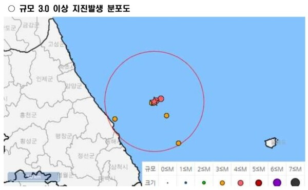
It was the 22nd-strongest quake ever detected on or around the Korean Peninsula.
Also, it was the strongest quake by magnitude out of the 42 quakes reported in the area since Korea began recording earthquakes in 1978.
According to the KMA's estimate, Monday's quake might have come from an unidentified reverse fault on the East Sea.
Experts say Monday's quake might have to do with a nearby Hupo fault, unlike a series of small earthquakes in the area coming from an unidentified right-lateral fault, the movement of which is in the right-hand direction.
"This means we are not sure if the main shock in the area has already come or not," said Lee Hee-kwon, geology professor at Kangwon National University.
Work to identify the faults in ocean areas off the Korean Peninsula -- including the quake-hit area -- have been underway in a pangovernmental research project for the past couple of decades, but it is unlikely that Seoul will be able to confirm where the active faults in the area are in the near future, a KMA official told The Korea Herald on Monday.
Korea experienced its strongest earthquake with the magnitude of 5.9 in 2016 in Gyeongju, North Gyeongsang Province, causing damage to historical sites and artifacts as well as disrupting telecommunications operations.
It was followed by a 5.4-magnitude quake in Pohang, North Gyeongsang Province, in 2017, which left over 90 injured and displaced nearly 1,800.


![[KH Explains] Korean shipbuilding stocks rally: Real growth or bubble?](http://res.heraldm.com/phpwas/restmb_idxmake.php?idx=652&simg=/content/image/2024/04/25/20240425050656_0.jpg&u=)