
Most Popular
-
1
1 in 3 Koreans live alone, family types becoming diverse

-
2
Korea, Japan finance chiefs vow to tame rampant FX market volatility

-
3
K-pop group's manager dismissed for setting up spycam in theater dressing room

-
4
K-pop singer lost consciousness after being hit by foul ball, cancels show

-
5
Korean Muslim YouTuber's plan to build mosque in Incheon goes viral


![[Today’s K-pop] BTS pop-up event to come to Seoul](http://res.heraldm.com/phpwas/restmb_idxmake.php?idx=644&simg=/content/image/2024/04/17/20240417050734_0.jpg&u=)

Heavy rain expected across southern areas as Typhoon Chanthu approaches
By YonhapPublished : Sept. 13, 2021 - 11:04
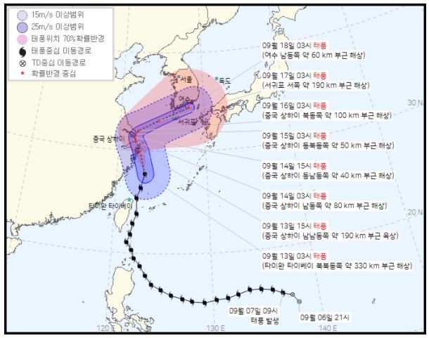
South Korea's southern areas will likely receive heavy rain Monday due to the indirect influence of Typhoon Chanthu, currently moving toward the waters near Shanghai, the state weather agency said.
The southern island of Jeju is forecast to see precipitation levels ranging between 30 mm to 50 mm per hour, with thunder and lightning expected on some parts of the island, due to the heavy winds from the typhoon approaching from the southwest, according to the Korea Meteorological Administration (KMA).
The southwestern South Jeolla Province is also expected to see downpours beginning Monday evening.
The KMA said Chanthu was located above waters 330 kilometers northeast of Taipei as of 3 a.m. Its maximum wind speed was recorded at 43 meters per second.
The storm will likely reach waters off Jeju Island and Korea's southern coast around Wednesday and Thursday, the agency added.
As the storm closes in on the Korean Peninsula, the rain is expected to affect other southern regions as well, including many parts of South Gyeongsang Province in the southeast and North Jeolla Province in the southwest Tuesday.
Precipitation levels could reach more than 500 mm in some parts of Jeju, 80 mm in South Jeolla Province and 40 mm in South Gyeongsang Province throughout Wednesday, according to the KMA. (Yonhap)


![[KH Explains] Hyundai's full hybrid edge to pay off amid slow transition to pure EVs](http://res.heraldm.com/phpwas/restmb_idxmake.php?idx=652&simg=/content/image/2024/04/18/20240418050645_0.jpg&u=20240418181020)

![[Today’s K-pop] Zico drops snippet of collaboration with Jennie](http://res.heraldm.com/phpwas/restmb_idxmake.php?idx=642&simg=/content/image/2024/04/18/20240418050702_0.jpg&u=)