
Most Popular
-
1
Yoon sorry for shortcomings but insists policies were right

-
2
1 in 3 Koreans live alone, family types becoming diverse

-
3
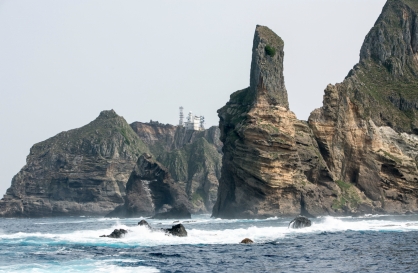
S. Korea ‘strongly’ protests Japan’s claim over Dokdo in diplomatic bluebook
-
4
US 'incredibly concerned' about suspected NK-Iran military ties

-
5
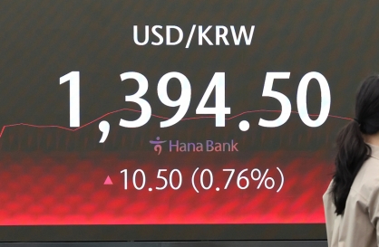
Korean won weakens amid heightened uncertainty


-
6
Korea, Japan finance chiefs vow to tame rampant FX market volatility

-
7
Seoul says will cut power to porn festival planned on Han River

-
8
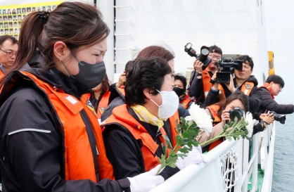
Sewol victims commemorated on tragedy's 10th anniversary
-
9
Chanel, Louis Vuitton see muted growth in Korea

-
10
K-pop group's manager dismissed for setting up spycam in theater dressing room


Korea’s environment-monitoring satellite sends first images
By Shim Woo-hyunPublished : May 11, 2020 - 17:40
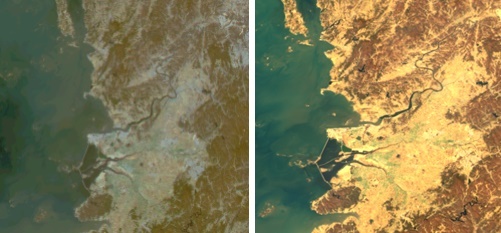
The Ministry of Science and ICT on Monday revealed photographs and videos sent from the nation’s environment-monitoring satellite Chollian 2B.
Chollian 2B is South Korea’s geostationary satellite. Launched on Feb. 19, it reached its designated orbit in March and currently sits in an orbital band above the Korean Peninsula.
The latest images and videos sent from the satellite showed land and water in the Northeast Asian region, taken during camera tests between April 21 and 22.
“The ministry has confirmed that the satellite is now operating without any mechanical issues. The satellite will be able to send clearer images and videos when it optimizes its camera settings,” the ICT Ministry said.
The satellite, equipped with enhanced sensors, will be able to quickly detect and send images when there are changes in seaside facilities or water quality, the ICT Ministry said. The satellite images will also help authorities respond to oil spills, the ministry added.
Chollian 2B is capable of taking photographs with a spatial resolution four times higher than photos from Chollian 1 -- another Korean satellite for oceanography and meteorological Earth observation launched in 2010.
Its sensors can detect ultraviolet and infrared light that is invisible to the naked eye. The sensors will pick up changes in the ocean’s chlorophyll, marine pollutants and other factors in the maritime ecosystem.
In October, Chollian 2B will officially start providing maritime images through the Ministry of Oceans and Fisheries. The ICT Ministry will also unveil satellite images containing atmospheric information.
By Shim Woo-hyun (ws@heraldcorp.com)


![[Today’s K-pop] BTS pop-up event to come to Seoul](http://res.heraldm.com/phpwas/restmb_idxmake.php?idx=642&simg=/content/image/2024/04/17/20240417050734_0.jpg&u=)