Most Popular
-
1
Korea’s homegrown nanosatellite successfully launches into space

-
2
[Herald Interview] 'Amid aging population, Korea to invite more young professionals from overseas'
![[Herald Interview] 'Amid aging population, Korea to invite more young professionals from overseas'](//res.heraldm.com/phpwas/restmb_idxmake.php?idx=644&simg=/content/image/2024/04/24/20240424050844_0.jpg&u=20240424200058)
-
3
Nicaragua shuts down Seoul embassy

-
4
Hybe's multilabel system tested amid conflict with Ador

-
5
Rocket engine expert, ex-NASA exec to lead Korea's new space agency


![[Herald Interview] 'Amid aging population, Korea to invite more young professionals from overseas'](http://res.heraldm.com/phpwas/restmb_idxmake.php?idx=644&simg=/content/image/2024/04/24/20240424050844_0.jpg&u=20240424200058)


-
6
SNU profs to suspend treatment for one day
-
7
SK hynix pledges W20tr to ramp up DRAM production at home

-
8
Over-50s, men, single-person households take up majority of those filing for bankruptcy

-
9
Ministry denies blame for Jamboree debacle

-
10
Pianist Cho Seong-Jin named Berlin Philharmonic's artist-in-residence


Typhoon Mitag is approaching the Korean Peninsula faster than initially forecast and may hit the southern region as early as Wednesday afternoon.
The Korea Meteorological Administration said Tuesday the typhoon is forecast to hit Jeju Island on Wednesday afternoon before moving up the peninsula’s west coast, making landfall in the coastal area of South Jeolla Province by midnight.
The Korea Meteorological Administration said Tuesday the typhoon is forecast to hit Jeju Island on Wednesday afternoon before moving up the peninsula’s west coast, making landfall in the coastal area of South Jeolla Province by midnight.
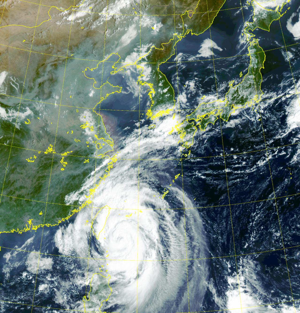
The weather agency projected the storm will sweep across the nation eastwards and exit into the East Sea around Thursday afternoon.
Mitag’s central pressure was reported to be 970 hectopascals, with a maximum wind speed of 35 meters per second.
Although the midsize storm is weakening in strength as it passes through the cooler parts of the water near China, the weather agency warned of damages as it is expected to scrape through the inland overnight.
The typhoon is expected to bring up to 600 millimeters of rain on Jeju and 100-300 mm to South Gyeongsang and South Jeolla provinces as well as the eastern coastal areas between Wednesday and Friday.
By Choi Ji-won (jwc@heraldcorp.com)


![[KH Explains] Korean shipbuilding stocks rally: Real growth or bubble?](http://res.heraldm.com/phpwas/restmb_idxmake.php?idx=652&simg=/content/image/2024/04/25/20240425050656_0.jpg&u=)