
Most Popular
-
1
Yoon sorry for shortcomings but insists policies were right

-
2
1 in 3 Koreans live alone, family types becoming diverse

-
3
S. Korea ‘strongly’ protests Japan’s claim over Dokdo in diplomatic bluebook
-
4
Korea, Japan finance chiefs vow to tame rampant FX market volatility

-
5
US 'incredibly concerned' about suspected NK-Iran military ties


-
6
Korean won weakens amid heightened uncertainty

-
7
Seoul says will cut power to porn festival planned on Han River

-
8
Sewol victims commemorated on tragedy's 10th anniversary

-
9
K-pop group's manager dismissed for setting up spycam in theater dressing room

-
10
Chanel, Louis Vuitton see muted growth in Korea


Rapidly intensifying Hurricane Florence could strike a direct and dangerous blow anywhere from the Carolinas to the Mid-Atlantic region later this week, possibly as a fearsome category 4.
A hurricane hunter plane found Florence strengthening quickly, reaching top winds of 85 mph (140 kph) Sunday evening after crossing the 74 mph threshold from tropical storm to a hurricane earlier in the day.
Forecasters said Florence was expected to become an extremely dangerous major hurricane sometime Monday, and remain that way for days.
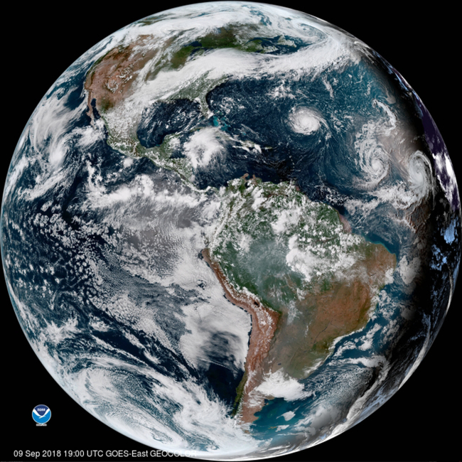
As of 5 a.m. EDT, Florence was centered about 625 miles (1,005 kilometers) southeast of Bermuda, moving west at 9 mph (15 kph). Its maximum sustained winds are at 105 mph (165 kph). Drawing energy from the warm water, it could have top sustained winds of 130 mph (209 kph) or more by Tuesday, the Miami-based center said.
The center also said that Hurricane Isaac, much farther out to sea, has become the 5th named hurricane of the 2018 Atlantic season.
It's too early to know the exact path, but forecasters said Florence could blow ashore in the Carolinas by Thursday.
Up and down the densely populated coast, residents have been told to prepare, and not just for a possible direct blow. Florence could slow or stall on or near shore, scooping up massive amounts of seawater. Some forecasting models show it could unload a foot or two of rain in places, causing devastating inland flooding. Forecasters also warned of a rising threat of life-threatening storm surge, along with the damaging winds.
The governors of North and South Carolina and Virginia declared states of emergency far ahead of the approaching storm.
Navy ships off Virginia's coast were preparing to sail out of the path, a North Carolina university has already canceled classes and people have begun stocking up on plywood, bottled water and other supplies.
Red flags have already been flying on beaches, warning swimmers to stay out of the water as seas began kicking up. People rushed to get emergency kits ready, map out escape routes, fill sandbags and secure their homes.
"Pretend, assume, presume that a major hurricane is going to hit right smack dab in the middle of South Carolina and is going to go way inshore,'' South Carolina Gov. Henry McMaster said. The state's emergency management agency said it is "preparing for the possibility of a large-scale disaster.''
In coastal Charleston, South Carolina, city officials offered sandbags to residents. Myrtle Beach Mayor Brenda Bethune urged people to secure their homes but said it was too early to know if evacuations will be ordered.
Myrtle Beach hardware stores and supermarkets were busy ringing up sales of bottled water, plywood and generators.
"Literally, they are filling buggies full of water, shopping carts full of water,'' Ryan Deeck, grocery department manager at a Walmart, told The Sun News. "They're coming in and buying water and plates, and that's about all they're buying." (AP)


![[Today’s K-pop] BTS pop-up event to come to Seoul](http://res.heraldm.com/phpwas/restmb_idxmake.php?idx=642&simg=/content/image/2024/04/17/20240417050734_0.jpg&u=)