
Most Popular
-
1
1 in 3 Koreans live alone, family types becoming diverse

-
2
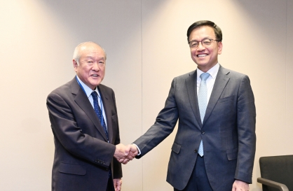
Korea, Japan finance chiefs vow to tame rampant FX market volatility
-
3
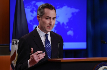
US 'incredibly concerned' about suspected NK-Iran military ties
-
4
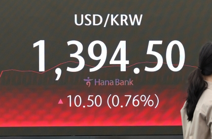
Korean won weakens amid heightened uncertainty
-
5
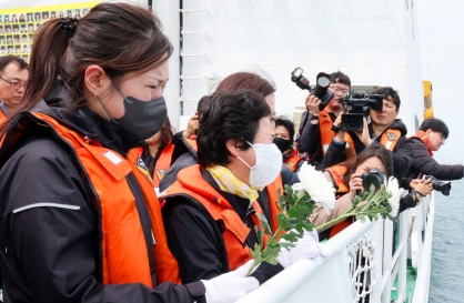
Sewol victims commemorated on tragedy's 10th anniversary


-
6
K-pop group's manager dismissed for setting up spycam in theater dressing room

-
7
Chanel, Louis Vuitton see muted growth in Korea

-
8
K-pop singer lost consciousness after being hit by foul ball, cancels show

-
9
Conservative bloc divided over Han’s role in election defeat

-
10
Korean Muslim YouTuber's plan to build mosque in Incheon goes viral


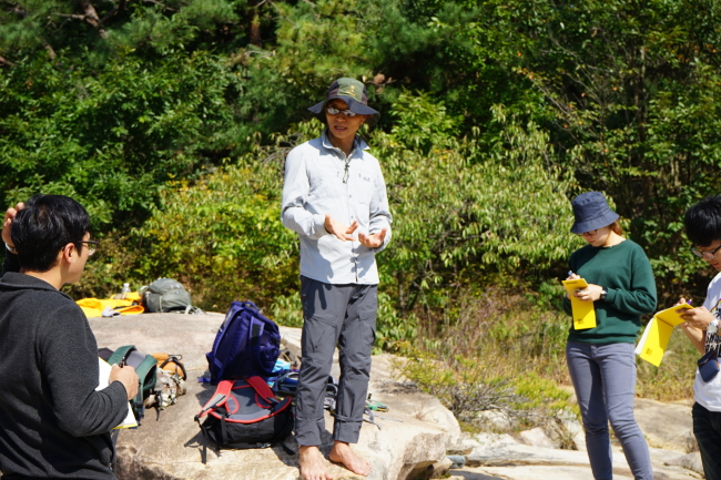
[Herald Interview] Despite urgency, quest to unearth active faults face hurdles
Expert calls for public support on 25-year project to trace source of another earthquake in future
By Son Ji-hyoungPublished : March 2, 2018 - 15:19
For centuries, Korea has been a quake-free zone, but recent events have caused that to change.
Of the 10 earthquakes in South Korea that registered 5.0 or higher on the Richter scale in its four decades of state measurement, half occurred after the 2011 Tohoku earthquake off the coast of Japan.
The record 9.1-magnitude undersea quake, a subsequent seismic sea wave or tsunami and aftershocks have claimed over 15,000 lives in Japan. However, it also had an impact on tectonic activities in countries across the strait, including Korea.
The quake, also known as the Great East Japan Earthquake, appears to have accelerated a stress build-up in faults on the Korean Peninsula and put forward a release of the accumulated energy associated with motions on active faults, causing earthquakes especially in southeastern part of the nation in recent years, said Kim Young-seog, a geology professor at Pukyong National University, in an interview with The Korea Herald.
But Korea still has no clue where the next target will be, or when it could happen again, he said, as the public sense of the nation being a quake-free zone has hindered development of geology and earthquake research.
A creation of a fault line map of the peninsula is crucial, to prevent the construction of buildings at or near zones with a high degree of an earthquake risk.
But the grand project, which will take at least 20 years to complete, only begun last year in the wake of Gyeongju earthquake.
“The government began to practically allocate a budget (for drawing a fault line map) after an earthquake hit Gyeongju, and that‘s when a discussion for a new project gained momentum,” Kim said. “However, it‘s too late to blame a certain entity for not trying 20-30 years ago.”
The void of the system invited confusion, especially in finding out the exact hypocenter of the quakes in Pohang.
The Korea Meteorological Administration was met with criticism after picking a fault line 7 kilometers away from the epicenter as the hypocenter. Academic circles have conceded that an unidentified active fault near Pohang caused the earthquake.
The confusion shed light on a 25-year project that Korea‘s Ministry of the Interior and Safety has embarked on, to secure locations of quake-prone fault lines since July 2017. Kim is currently a director of a team involved in the project, made up of 11 professors and 54 researchers from seven universities and two state-led institutions.
Backed by at most a 15 billion won ($13.9 million) budget, the team in the first five years plans to discover faults in North and South Gyeongsang Province, closest to Japan. The team will also make use of data gathered from Light Detection and Ranging, a remote sensing method to measure geographic features. In the next round of five years, the project will revolve around Seoul and the surrounding metropolitan area, according to a preliminary plan.
The process of identifying the active fault lines will be modeled after those of Japan and the United States, while the degree of activity will be graded following a guideline suggested by the government. Faults will be segmented according to the level of activity and designated a grade on the scale of 4. The fault, whose latest earthquake occurred in late Pleistocene era, or at most 126,000 years ago, will be considered active and will be given the grade of 1 or 2, according to the guideline.

Kim called it an extremely complex and enduring process, particularly considering a lack of manpower in Korea, which “could not be offset by abundant funding.”
But the fact that, until 2041, the nation would not be aware of the location of active faults -- estimated to be as many as 450 -- stirred public dissatisfaction and calls for swift progress.
Kim said it is “meaningless to act in a rush.” Kim stressed that a failure in a previous attempt led by the Korea Institute of Geoscience and Mineral Resources should not repeat.
For three years from 2009, a project to locate active faults was underway with 2 billion won of subsidies. But the result has remained closed to the public since 2012 without revealing it to public, after doubts on credibility of the survey result emerged, while a team involved in a project demanded an extension of time and financial support for the project.
“From the beginning, it was impossible to locate active faults in a three-year project with a low budget,” Kim said.
He also cited the length of time a similar project in Japan required.
“It took nearly 20 years for Japan to create a fault line map, despite richer human resources compared to those of Korea and academic advances it had achieved.”
He also pointed to mediocre public awareness of the issue he had to cope with, even after a series of earthquakes and aftershocks on the peninsula.
For example, for paleoseismic trenching, excavating privately-owned lands is inevitable, he said. But without consent, such an act is deemed a breach of private property.
“Without a land owner’s cooperation, the project is impossible to progress,” said Kim, while calling for the nation to legally allow the process through a new bill.
When asked about academic criticism on the project that its research mainly revolves around the surface of a tectonic plate in the nation not used to earthquakes, Kim said identifying faults with their traces visible on the surface could subsequently give subsurface clues.
By Son Ji-hyoung
(consnow@heraldcorp.com)


![[Today’s K-pop] BTS pop-up event to come to Seoul](http://res.heraldm.com/phpwas/restmb_idxmake.php?idx=642&simg=/content/image/2024/04/17/20240417050734_0.jpg&u=)