Most Popular
-
1
1 in 3 Koreans live alone, family types becoming diverse

-
2
Korea, Japan finance chiefs vow to tame rampant FX market volatility

-
3
K-pop group's manager dismissed for setting up spycam in theater dressing room

-
4
Contentious grain bill put directly to plenary meeting for vote

-
5
Korean Muslim YouTuber's plan to build mosque in Incheon goes viral


![[Today’s K-pop] BTS pop-up event to come to Seoul](http://res.heraldm.com/phpwas/restmb_idxmake.php?idx=644&simg=/content/image/2024/04/17/20240417050734_0.jpg&u=)

[Weekender] Walk across a land frozen in time
Nature trail in the DMZ offers unusual experience of strolling on land little touched by men for more than 60 years
By Korea HeraldPublished : March 3, 2017 - 18:34
CHEORWON, Gangwon Province -- Venturing deep inside the remote county of Cheorwon, Gangwon Province, one finds the village of Gimhwa-eup, just a stone’s throw away from the inter-Korean border.
Here lies the Demilitarized Zone, a no man’s land set as a buffer zone between the Koreas on July 27, 1953 when the US, representing the United Nations Command, and North Korea reached an armistice agreement that brought a truce to the Korean Peninsula.
Nearly 64 years on, the DMZ remains uninhabited, save for soldiers standing guard.
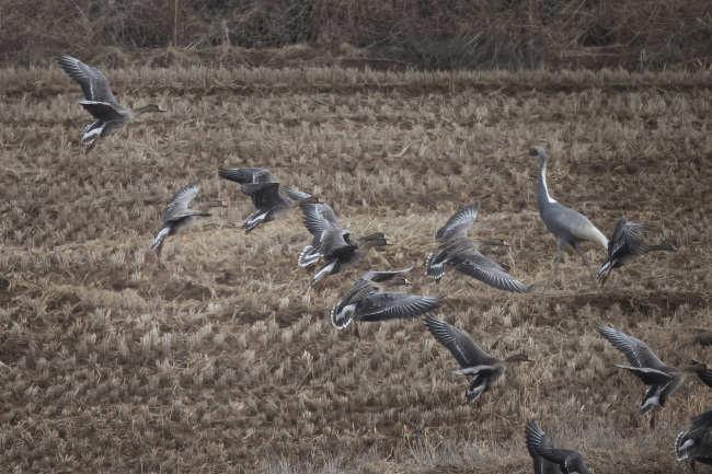
“We get a flock of cranes and swans here in December. Some people visit just to take a picture of the wildlife and nature,” said Lee Seung-il, an official of Cheorwon dispatched to manage the DMZ Eco Peace Park Trail.
The trail was created by an agreement among Cheorwon, the Ministry of National Defense and the Ministry of Environment to “demonstrate the DMZ and the state of coexistence among peace, nature and war,” according to officials.
A stroll around the trail is an odd experience, as though peeking into the life of a rural village in the 1970s -- except of course, for the pavement and out-of-place-looking utility poles.
Taking the trail toward the Yongyang reservoir, one comes across Namdae-cheon. Over the stream is a stone bridge that appears to be crumbling before your very eyes.
“Before the (Korean) war, this was the most populated area around here. So the bridge was used a lot,” said Lee. The bridge was also used by Koreans fleeing to the South during the Korean War.
Here lies the Demilitarized Zone, a no man’s land set as a buffer zone between the Koreas on July 27, 1953 when the US, representing the United Nations Command, and North Korea reached an armistice agreement that brought a truce to the Korean Peninsula.
Nearly 64 years on, the DMZ remains uninhabited, save for soldiers standing guard.
“We get a flock of cranes and swans here in December. Some people visit just to take a picture of the wildlife and nature,” said Lee Seung-il, an official of Cheorwon dispatched to manage the DMZ Eco Peace Park Trail.
The trail was created by an agreement among Cheorwon, the Ministry of National Defense and the Ministry of Environment to “demonstrate the DMZ and the state of coexistence among peace, nature and war,” according to officials.
A stroll around the trail is an odd experience, as though peeking into the life of a rural village in the 1970s -- except of course, for the pavement and out-of-place-looking utility poles.
Taking the trail toward the Yongyang reservoir, one comes across Namdae-cheon. Over the stream is a stone bridge that appears to be crumbling before your very eyes.
“Before the (Korean) war, this was the most populated area around here. So the bridge was used a lot,” said Lee. The bridge was also used by Koreans fleeing to the South during the Korean War.
After coming under military control, Amjeong bridge was used predominantly by soldiers and farmers who worked at the fields within the DMZ and left at the end of the day. The bridge was decommissioned in 1998, as authorities found it unsafe for vehicles to drive on it, as it was built in around 1930.
The precarious bridge, along with a road sign that bears a prewar name for Gimhwa County, is a reminder of how little the area has been touched by humans.
Turning left from the bridge, one finds a military outpost that conducts checks on anyone entering or leaving the DMZ. Prior to visiting the DMZ Eco Peace Park Trail, guests must submit their names, phone number, address and other information to the officials running the trail, two days prior to their visit.
The information is then submitted to the military for it to keep tabs on who goes in and out of the military-managed area.
The presence of military facilities near the trail, which cannot be photographed, is a chilling reminder that the DMZ sits just kilometers away from one of the most reclusive and repressive regimes in the world.
This becomes more apparent near Yongyang reservoir near the border, which is behind barbwire fences and an Army base.
“Warning! Landmines installed in the past have been found in this area. The mines are often found behind the bushy areas and behind the rocks. Entering the area is strictly forbidden,” reads a stern sign near the fields, prompting onlookers to glance at innocent-looking bushes nearby with newfound alert.
Apart from the soldiers and military facilities, walking along the trail is generally a peaceful experience. The road leading back to the outpost at the starting point of the trail is surrounded by trees and offers the serenity of walking on a road that is almost completely devoid of other people.
The path toward Yongyang reservoir is a walking trail that takes less than two hours to complete. The other path toward the “Cross Tower” in the mountains is a hiking trail that takes about three hours.
By Yoon Min-sik (minsikyoon@heraldcorp.com)
-
Articles by Korea Herald


![[KH Explains] Hyundai's full hybrid edge to pay off amid slow transition to pure EVs](http://res.heraldm.com/phpwas/restmb_idxmake.php?idx=652&simg=/content/image/2024/04/18/20240418050645_0.jpg&u=20240419100350)