

Most Popular


![[KH Explains] How should Korea adjust its trade defenses against Chinese EVs?](http://res.heraldm.com/phpwas/restmb_idxmake.php?idx=644&simg=/content/image/2024/04/15/20240415050562_0.jpg&u=20240415144419)


CHICAGO (AP) ― Many people use smartphone apps to map their drive to dinner or find a less-congested route to work. But did you know that you can use them for public transit, too? You can even access some maps offline, when you have a spotty connection or are in the subway.
Here’s a look at what leading free map apps can do for you, whatever mode of transportation you choose:
Bumper to bumper
Most major map apps show you current traffic conditions. The best guide you toward a little-known shortcut or less-obvious route to avoid congestion.
If you’re in a traffic mecca such as Los Angeles, Waze is the app for you. Users update the map with the latest conditions, even reporting cars parked on the shoulder. Over the summer, several relatives and I left at the same time in three different cars for a theater in Hollywood. Only the driver using Waze got there in time. Google bought Waze last year, so Google Maps now factors in Waze’s user contributions, too.
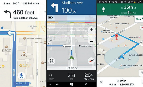
The Here app for Windows also will help you find the speediest route. But it doesn’t want you to get a ticket. The app knows speed limits for various roads and will beep when you go over, even by a small amount. (My travel companion turned that feature off by the first rest stop on a weekend trip to New Hampshire.)
Here’s a look at what leading free map apps can do for you, whatever mode of transportation you choose:
Bumper to bumper
Most major map apps show you current traffic conditions. The best guide you toward a little-known shortcut or less-obvious route to avoid congestion.
If you’re in a traffic mecca such as Los Angeles, Waze is the app for you. Users update the map with the latest conditions, even reporting cars parked on the shoulder. Over the summer, several relatives and I left at the same time in three different cars for a theater in Hollywood. Only the driver using Waze got there in time. Google bought Waze last year, so Google Maps now factors in Waze’s user contributions, too.
The Here app for Windows also will help you find the speediest route. But it doesn’t want you to get a ticket. The app knows speed limits for various roads and will beep when you go over, even by a small amount. (My travel companion turned that feature off by the first rest stop on a weekend trip to New Hampshire.)
Taking a stroll?
Map apps give you the choice to input what mode of transportation you plan to take on your route. It’s worth clicking “walk” if you’re hoofing it to your destination. Otherwise you might end up on a six-lane highway, miss shortcuts such as recreational paths and go out of your way taking one-way streets. I eliminated a one-block detour using Google Maps’ walk-specific directions to visit a friend in Chicago, for instance.
Apple Maps is very user-friendly for walkers. As you walk, the distance displayed decreases, but the map itself doesn’t change. That confused me at first, but I came to appreciate it. Other apps tend to constantly refresh depending on where you are and how you’re holding the phone, which can be headache-inducing as you move your hand or arms. With Apple Maps, the direction you should be heading toward is on top, and the streets are fixed on right angles.
Public transit
If you choose transit on Google Maps, it will include the walk to and from the bus or subway stop in its directions. Apple Maps doesn’t offer transit directions, but it will suggest transit apps you can install. I’ve been a fan of HopStop, one of the first transit apps, though I typically gravitate back to Google because it offers driving and walking directions in the same app.
Syncing with personal computers
You’re comparing restaurants on your laptop at home, and you don’t want to duplicate efforts when you leave the house. If you use Apple Maps, you can research places and directions on the Mac’s Maps app and hit a share button to send the destination to your iPhone or iPad. From the mobile device, you simply tap on that location to get voice-guided directions.
Google offers something similar, though it’s not as precise in practice. If I look up a destination on Google Maps on a Mac or Windows computer, the place is usually already there when I check my phone, as long as I’ve signed in to my Google account. It’s more automated than Apple’s approach, but sometimes the destination I need isn’t there. Other times, the app is cluttered with places I’ve searched for before but wasn’t necessarily intending to go to.
Either way, it beats retyping everything on a phone’s small keyboard.


![[Today’s K-pop] Stray Kids to return soon: report](http://res.heraldm.com/phpwas/restmb_idxmake.php?idx=642&simg=/content/image/2024/04/16/20240416050713_0.jpg&u=)