Most Popular
-
1
[Exclusive] Korean military set to ban iPhones over 'security' concerns
![[Exclusive] Korean military set to ban iPhones over 'security' concerns](//res.heraldm.com/phpwas/restmb_idxmake.php?idx=644&simg=/content/image/2024/04/23/20240423050599_0.jpg&u=20240423183955)
-
2
Korean, Romanian leaders discuss defense tech, nuclear energy

-
3
S. Korea calls on Japan to confront history amid Yasukuni Shrine visit

-
4
Yoon’s jailed mother-in-law excluded from latest parole list

-
5
Hybe and Min Hee-jin, CEO of Hybe sublabel Ador, lock horns

![[Exclusive] Korean military set to ban iPhones over 'security' concerns](http://res.heraldm.com/phpwas/restmb_idxmake.php?idx=644&simg=/content/image/2024/04/23/20240423050599_0.jpg&u=20240423183955)


-
6
[Herald Interview] 'Amid aging population, Korea to invite more young professionals from overseas'
![[Herald Interview] 'Amid aging population, Korea to invite more young professionals from overseas'](//res.heraldm.com/phpwas/restmb_idxmake.php?idx=644&simg=/content/image/2024/04/24/20240424050844_0.jpg&u=20240424200058)
-
7
Korea’s homegrown nanosatellite successfully launches into space

-
8
[Pressure points] Leggings in public: Fashion statement or social faux pas?
![[Pressure points] Leggings in public: Fashion statement or social faux pas?](//res.heraldm.com/phpwas/restmb_idxmake.php?idx=644&simg=/content/image/2024/04/23/20240423050669_0.jpg&u=)
-
9
Nicaragua shuts down Seoul embassy

-
10
Rocket engine expert, ex-NASA exec to lead Korea's new space agency

![[Herald Interview] 'Amid aging population, Korea to invite more young professionals from overseas'](http://res.heraldm.com/phpwas/restmb_idxmake.php?idx=644&simg=/content/image/2024/04/24/20240424050844_0.jpg&u=20240424200058)

![[Pressure points] Leggings in public: Fashion statement or social faux pas?](http://res.heraldm.com/phpwas/restmb_idxmake.php?idx=644&simg=/content/image/2024/04/23/20240423050669_0.jpg&u=)


Finding history at colorful Kaymoor in West Virginia’s New River Gorge
By Korea HeraldPublished : March 21, 2014 - 19:42
FAYETTEVILLE, West Virginia ― My first on-land visit to historic Kaymoor was before trails existed.
Friend David Arnold led me on a killer bushwhacking hike in the 300-meter-deep New River Gorge 30 years ago to get to the old coal camp and take photographs of the mining equipment and infrastructure.
It was one of the most visible old mining communities along the New River. There was a large coal operation from 1900 to 1962 at what was called Kaymoor No. 1 mine.
Its headhouse near the entrances to the coal seam clung to the gorge’s steep slope. This was where coal was loaded onto a double-tracked incline to descend 170 meters to the tipple, where it would be sorted and loaded onto rail cars. Old buildings, railroad tracks and coke ovens once sat by the river. Dave and I and other raft guides floated past Kaymoor on the New River and told our customers of the town’s colorful history.
We had started our hike near the New River Gorge Bridge. It was cold and icy and the hiking was not easy. Thickets of vegetation made the cross-gorge hike more difficult. Sandstone cliffs barred our way in some spots. The slopes were steep.
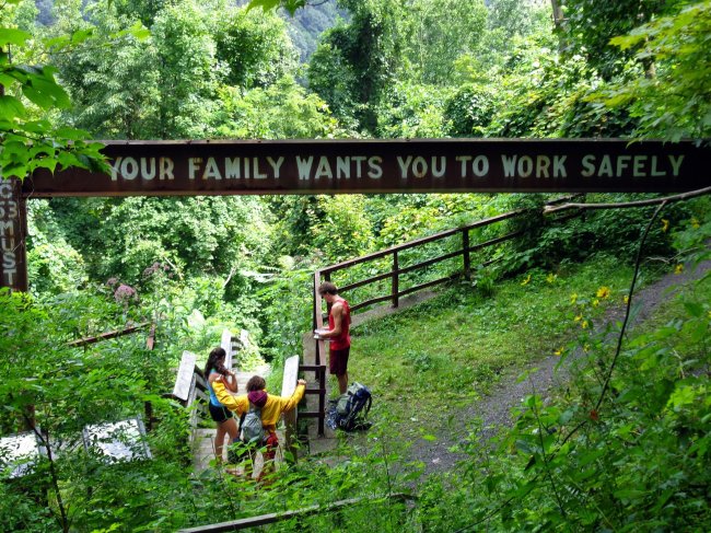
But we made it the 3.2 kilometers. We inspected the old buildings at Kaymoor, the dark holes of the mine entrances and fading signs encouraging miners to work safely.
Today it is much easier to get to Kaymoor, one of the historic centerpieces of the New River Gorge National River. That designation covers 85 kilometers of the river and 30,000 hectares in south-central West Virginia.
There were actually two Kaymoors at the No. 1 mine: Kaymoor Top at the canyon rim and Kaymoor Bottom by the river. There were also upper and lower towns at Kaymoor No. 2, about 3 kilometers closer to the New River Gorge Bridge.
The Kaymoor No. 1 mine produced nearly 17 million tons of bituminous coal in its 62 years, the park service says. No. 2 was less successful and closed in 1925.
The National Park Service has developed three trail options to get to Kaymoor.
I love the historic Kaymoor Miner’s Trail outside of Fayetteville on the canyon’s west rim at a trailhead called Kaymoor Top, about 100 kilometers east of Charleston and 4.5 hours from Akron.
It is a steep hike that drops 120 meters in about a kilometer to reach two mine entrances to the Sewell coal seam, and the remains of some of the old buildings and equipment. It is the shortest route to Kaymoor, but not an easy hike. There are ferns, wildflowers, waterfalls, rock outcroppings, some long-distance vistas and seven switchbacks.
You can gaze across the gorge at the bare sandstone cliffs known as the Endless Wall.
Hundreds of coal miners once used this trail. They hiked down to the mine and at the end of the day, back up to their homes at the edge of the gorge.
Later a single-track mountain haulage or car with a steam-powered cable hoisting drum was built to connect Kaymoor Top and Kaymoor Bottom. It could haul up to 15 people at a time. Two miners were killed in a 1913 haulage accident.
Today the mine entrances at what’s called Sewell Bench are sealed off with bars to make sure that no one gets hurt inside.
A warning is painted on a 8.5-meter-long steel I-beam in white letters: “Your Family Wants You to Work Safely.”
Nearby is what’s left of the mine’s powder house. It is 6 meters by 5.5 meters with walls of stone a foot thick.
Visitors can then descend 821 wooden steps to reach Kaymoor Bottom at river level. But it is a steep and difficult return climb up those steps. It is just short of a kilometer down and back up.
At the bottom, park visitors will see the ruins of 202 beehive ovens that were used to turn coal into coke for iron making. The coal was removed from the mine by mule-powered rail cars. Later locomotives replaced the mules.
The coal was moved to the wooden headhouse. That structure was built in 1899 and has collapsed, although its foundation can still be seen.
The coal was lowered 300 meters on a double-tracked gravity incline along a 30-degree slope to the tipple that sat by the main railroad tracks next to the New River.
Initially, Kaymoor Bottom had 120 coke ovens. More were added during World War I. They were abandoned in the 1930s.
There are the remains of old houses, mine buildings and rail sidings. Much of the site is overgrown with vegetation.
Kaymoor ― it is sometimes spelled Kay Moor ― was started by the Low Moor Iron Co. of Low Moor, Virgina. It employed 800 miners at its peak.
The land was purchased by Low Moor Iron in 1873 when the railroad came to the New River Gorge. But Low Moor kept the site in reserve until 1899. Work on the mines began that year and the first coal was shipped in 1900. Kaymoor was sold in 1925 to the New River and Pocahontas Consolidated Coal Co.
Kaymoor was a company-run, bare-bones town. Families lived in four-room bungalows. Some had running water and electricity, but all relied on privies.
There were no churches, banks, town halls, saloons, streetlights or sidewalks. There were company stores and segregated schools at the top and bottom, and a theater and tennis court. The post office was in a company store.
The company built 50 houses in 1901, 45 in 1902 and 17 in 1905 for miners and their families. Later New Camp was added with 24 houses on the canyon rim. There was a boarding house for 15 single miners costing 55 cents a day.
In 1923, there were 131 houses at Kaymoor. The town had 560 residents with 140 employed in the mine.
Kaymoor Bottom was largely abandoned by 1952 and was hit by a fire in 1960.
Kaymoor, covering 29 hectares, was added to the prestigious National Register of Historic Places in 1990.
Today there are two additional hiking routes to get to Kaymoor, but you can’t drive there.
There are two fairly level bike trails: one begins at the Cunard Access Road and the second begins off Fayette Station Road. It is 10 kilometers one-way from Cunard to Kaymoor, 3.4 kilometers one-way from Fayette Station Road to Kaymoor. That 3.4-kilometer route is roughly what I had hiked 30 years ago.
By Bob Downing
(Akron Beacon Journal)
(MCT Information Services)
-
Articles by Korea Herald