Most Popular
-
1
[Exclusive] Korean military set to ban iPhones over 'security' concerns
![[Exclusive] Korean military set to ban iPhones over 'security' concerns](//res.heraldm.com/phpwas/restmb_idxmake.php?idx=644&simg=/content/image/2024/04/23/20240423050599_0.jpg&u=20240423183955)
-
2
Korean, Romanian leaders discuss defense tech, nuclear energy
-
3
[Graphic News] 77% of young Koreans still financially dependent
![[Graphic News] 77% of young Koreans still financially dependent](//res.heraldm.com/phpwas/restmb_idxmake.php?idx=644&simg=/content/image/2024/04/22/20240422050762_0.gif&u=)
-
4
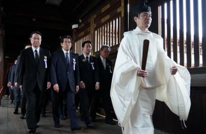
S. Korea calls on Japan to confront history amid Yasukuni Shrine visit
-
5
Yoon’s jailed mother-in-law excluded from latest parole list

![[Exclusive] Korean military set to ban iPhones over 'security' concerns](http://res.heraldm.com/phpwas/restmb_idxmake.php?idx=644&simg=/content/image/2024/04/23/20240423050599_0.jpg&u=20240423183955)

![[Graphic News] 77% of young Koreans still financially dependent](http://res.heraldm.com/phpwas/restmb_idxmake.php?idx=644&simg=/content/image/2024/04/22/20240422050762_0.gif&u=)


-
6
Hybe and Min Hee-jin, CEO of Hybe sublabel Ador, lock horns

-
7
[Pressure points] Leggings in public: Fashion statement or social faux pas?
![[Pressure points] Leggings in public: Fashion statement or social faux pas?](//res.heraldm.com/phpwas/restmb_idxmake.php?idx=644&simg=/content/image/2024/04/23/20240423050669_0.jpg&u=)
-
8
Yoo Jae-suk, Yoo Yeon-seok team up in 'Whenever Possible'

-
9
Aging population to drive down Korea's housing prices from 2040: experts
-
10
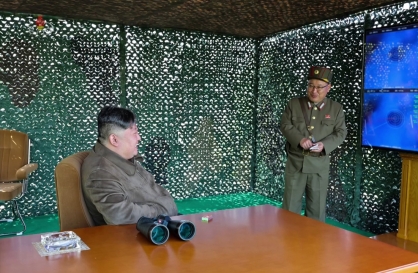
North Korea holds drills simulating nuclear counterattack against enemy

![[Pressure points] Leggings in public: Fashion statement or social faux pas?](http://res.heraldm.com/phpwas/restmb_idxmake.php?idx=644&simg=/content/image/2024/04/23/20240423050669_0.jpg&u=)


Japan’s old textbooks show Dokdo as Korean territory
By Claire LeePublished : Aug. 28, 2012 - 17:24
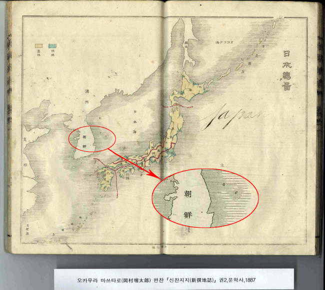
Japanese textbooks from the late 19th century, written and published by the country’s Culture Ministry at the time, indicate Dokdo as Korean territory, the Independence Hall of Korea announced on Tuesday.
The state institution said the textbooks ― mostly from the 1880s and some from the early 1900s ― prove that Japan’s current claim over the islets is false.
Japan has been arguing that Dokdo has always been part of Japan’s territory, even before it officially named the islets Takeshima and placed it under the Shimane Prefecture on Feb. 22, 1905.
“These books were written and published by the Japanese government at the time,” said the Independence Hall of Korea institution, after unveiling five textbooks and two sets of maps of Japan to the public. All of the Japanese documents clearly indicate Dokdo as Korean territory, according to the institution.
“This shows that the Japanese government did not consider Dokdo as part of their territory before Japan took over the islets during the Russo-Japanese War in 1905. This is another clear proof that Japan stole Dokdo even before it annexed Korea.”
Korea-Japan relations have soured after President Lee Myung-bak made a visit to Dokdo on Aug. 10. Following Lee’s visit, Japan proposed to Korea to jointly refer the issue of the islets to the International Court of Justice on Aug. 17.
Korea dismissed the proposal last week, saying that sovereignty over Dokdo is not in dispute and that it has always been Korea’s territory.
By Claire Lee
(dyc@heraldcorp.com)
<관련 한글 기사>
일본, '독도는 한국땅' 인정한 적 있다!
1905년 러•일 전쟁기에 일본이 독도를 강점하기 전까지 독도를 영토로 인식하지 않았던 사실이 일본정부에서 출판한 교과서 등을 통해서 확인됐다.
독립기념관이 28일 공개한 19세기말~20세기초 일본의 근대 교과서와 지도에는 독도가 일본 영토가 아니라는 내용이 담겨 있어, 한국의 독도 불법강점설을 주장하는 노다 요시히코(野田佳彦) 일본 총리의 주장도 허구라는 사실을 입증하고 있다.
이날 공개된 1887년 오카무라 마쓰다로가 편찬한 신찬지지(新撰地誌) 2권에 수록된 일본총도에는 일본 주변 섬을 가로줄 표기로 일본 영토임을 밝히면서 울릉도와 독도는 조선에 속한 땅으로 가로줄로 표기해 놓았다.
독도에서 157㎞ 떨어진 오키(隱岐)섬을 비롯한 일본 영토와 독도는 선명하게 구 별돼 있다.
문부성이 1905년 발행한 소학지리용신지도(小學地理用新地圖) 맨 앞면에 실린 대일본제국전도에도 류큐의 부속 섬은 물론 1894년부터 식민화한 대만, 일본 북부의 시마(千島) 열도까지 꼼꼼히 일본의 영토로 표시하고 있으나 독도는 포함되지 않았다.
1888년 학생용 지도책으로 간행 출판된 분방상밀일본지도(分邦詳密日本地圖)'는 당시 일본 전국을 상세하게 지역별로 구분한 지도인데 오키섬까지만 영토로 표시 돼 있다. 1878년 간행된 '일본지지요략(日本地誌要略)'에 수록된 '일본전도'도 마찬 가지다.
1905년은 일본이 독도를 시마네 현에 강제 편입한 해이나 같은 해 문부성에 해 발간된 지리 교과서에는 독도를 자국 영토로 표시하지 않았다.
1886년 나온 문부성 검정교과서 '일본사요(日本史要)'에도 대마도, 오키나와 등 주변 군도를 모두 자국 영토임을 주장했으나 독도에 대한 표기는 역시 나타나지 않고 있다.
반면 독도를 강점한 뒤 1925년 간행된 '표준일본지도'에는 울릉도는 '경상북도'로, 독도는 '시마네'라는 소속 관계가 명시돼 있다.
1800년대 후반 독도에 대한 영토의식이 전혀 없다가 영토의식이 생긴 1905년 이 후 제작한 지도 등에 독도(죽도)를 표기한 것으로 볼 수 있다.
일본은 1905년 2월22일 시마네 현 고시 이전에도 독도를 인지하고 실효적으로 지배해 왔다며 이를 근거로 국제법적 영토주권 확립이라고 주장해 왔다.
그러나 이날 공개된 자료에서 보듯 1905년 러ㆍ일 전쟁기에 독도를 강점하기 전 까지 독도를 일본 영토로 인식하지 않았고, 정부에서 출판한 교과서에도 독도를 일본 영토로 표시하지 않아 독도에 대한 영토의식이 전혀 없었음을 확인할 수 있다.
윤소영 연구위원은 "이번에 발굴 공개된 근대 일본의 역사•지리 교과서를 통해 독도가 역사적 고유영토라는 일본의 주장은 전혀 근거 없다는 것이 입증됐으며, 오히려 역사적으로 한국의 고유영토라는 사실을 증명해주고 있다"고 말했다.
이어 "1900년 대한제국 칙령 41호를 통해 이미 대한제국의 영토로 확인한 독도를 일본이 한국강점에 앞서 1905년에 강탈했던 역사적 맥락이 더욱 확연하게 드러났다"고 설명했다.